| Data set | Year | GPS | GT | IMU | Laser scanners | Images | Path length |
| Rawseeds [95] | 2006 | √ | √ | 1 | 2 horizontal (front: up to 100 m/rear: up to 30 m): 180°/0.25°@ 18 Hz 2 horizontal towards the ground (front/rear: up to 4 m): 240°/0.36°@ 10 Hz | Front: color 320 × 240@29.95 fps Omni.: b/w 640 × 64@ 15 fps Trino.: b/w 640 × 480@15 fps | Indoor: 0.89 km Outdoor: 1.9 km |
| New College and Oxford city | 2008 | √ | x | x | x | Mono: color 640 × 480@ ~1 fps | College: 2 km City: 28 km |
| center [99] New College [96] | 2009 | √ | x | √ | 2 vertical (left/right): 90°/0.5°@75 Hz | Stereo: b/w 512 × 384@20 fps Ladybug: 5 × (color 384 × 512@5 fps) | 2.2 km |
| Málaga data set [100] | 2009 | √ | 小 | √ | 1 horizontal tilting (front: up to 80 m): 180°/0.5°@37 Hz 2 horizontal (sides: up to 32 m): 180°/0.5°@37Hz 2 horizontal (front/rear: up to 30 m): 270°/0.25°@40Hz | Stereo: color 1024 × 768@7.5 fps | 6 km |
| MIT DARPA [101] | 2010 | √ | √ | √ | 7 horizontal (around the vehicle: up to 80 m):180°/0.25°@18 Hz 5 horizontal towards the ground (front: up to 80 m):180°/0.25°@18 Hz 13D 64-layer (up to 120 m):360°/0.09°/0.4°@10 Hz | Mono.: 4 × (color 376 × 240@10 fps) Mono.: color 752× 480@22.8 fps | 90 km |
| The Marulan data sets [102] | 2010 | √ | √ | √ | 1 horizontal (front: up to 80 m): 180°/0.25°@18Hz 1 vertical (front: up to 80 m): 180°/0.25°@18 Hz 2 horizontal towards the ground (front: up to 80 m): 180°/0.25° @18 Hz | Mono.: b/w 1360 × 1024@ 10 fps | ~1 km |
| Karlsruhe sequences [103] | 2011 | 小 | √ | √ | x | Stereo: b/w 1344 × 391 @ 10 fps | 6.9 km |
| Ford Campus [104] | 2011 | √ | √ | √ | 1 3D 64-layer (up to 120 m): 360°/0.09°/0.4°@10 Hz | Omni.: color 1600 × 600@8 fps | ~6 km |
| KITTI [97] | 2012 | √ | √ | √ | 1 3D 64-layer (up to 120 m): 360°/0.09°/0.4°@10 Hz | Stereo: b/w 1392 × 512@ 10 fps Stereo: color 1392 × 512@ 10 fps | ~50 km |
| Málaga Urban data set [98] | 2014 | √ | x | √ | 2 horizontal (front: up to 80 m): 180°/0.25°@18 Hz 2 vertical (sides: up to 30 m): 270°/0.25°@40 Hz 1 horizontal towards the ground (front: up to 30 m): 270°/0.25°@40 Hz | Stereo: color 1024 × 768@20 fps | 36.8 km |
Laser information includes field-of-view/horizontal resolution/vertical resolution. Ticks indicate the presence of a sensor. Crosses indicate its absence.
Regarding filtering methods, the divergence problem of the EKF SLAM has been stated numerous times. In [17], the authors show that the filter tends to give biased estimates when the linearization is performed far from the true value. It means that the uncertainty associated to the state (vehicle or map) is too small: the estimate is said to be inconsistent, the true value being out of the estimated uncertainty. The localization drifts progressively, the filter calculating a biased vehicle pose and map [110]. Non-linear models are not the only source of drift. Julier et al. in [16] add that the ignored correlation between data also provokes the divergence. Kalman Filters produce optimistic results, which means that they consider that a piece of data coming from a sensor is entirely new and so temporally decorrelated from the rest (white noise assumption) which is not the case and so contributes to the inconsistency.
The problems raised in this last paragraph also apply to optimization methods when they work in a local environment, which is a necessary condition for real-time estimation. The previously cited optimization-SLAM works also clearly show the importance of the rotation in that drift. It has been observed by multiple authors [111]. It has also been shown experimentally in [112] and [113]. In [114], the authors show that the 2D formulation of the SLAM problem is not convex and as such has local minima in which the optimization can be trapped. However, without including the rotation error, the problem is close to a quadratic function and thus becomes convex.
Many practical causes also affect the behavior of SLAM algorithms. For instance, the presence of dynamic obstacles when a static world assumption is a prerequisite is a factor. A low number of landmarks or the absence of sufficiently salient features in the scene can also induce wrong associations and so a divergence of the system. Of course, the accuracy of the models used with regard to noisy real sensor data is another factor that can have a strong impact on the integrity of the computed localization. Most of the works directly addressing this inconsistency problem tend to find ways to locally avoid or reduce the drift.
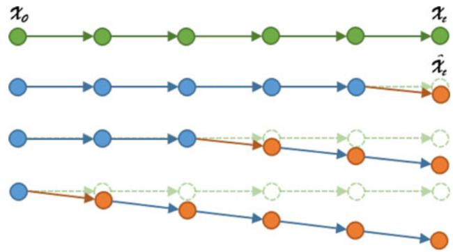
Fig. 4. Impact of an angular drift. In green, the ground truth of trajectory is picture. Below, example of an angular drift (orange arrow) occurring at different times on the estimation of the position.
## B. Avoiding or Reducing the Impact of Drift
The first possibility to avoid, or at least reduce, the divergence is to divide the map in submaps [31]. These approaches, presented before, break the global map in submaps where each one has its own reference frame. By doing so, the drift can be avoided at a local level by allowing only short trajectories per submap. The size of a submap must thus be calibrated and becomes a compromise between reducing the drift and dealing with the induced information loss. However, even with an appropriate size (see [35] for instance), there is no guarantee that the localization consistency will be preserved. Indeed, each measure contributes to make the system inconsistent and this phenomenon can occur even with a few pieces of data. Moreover, even if the divergence is avoided in the submaps, it is not the case in the global map that keeps track of how the submaps are connected. It is thus more of a local solution to the problem.
In a similar fashion, robot-centered approaches greatly reduce the divergence [115]. Instead of having a fixed world frame, the estimates are always given with relation to the vehicle position. Inconsistency problems are less frequent because they do not accumulate like it is usually the case. The estimation in this frame allows for a better consistency than in classical EKF SLAM [116]. Nevertheless, as with submaps, the divergence is not entirely resolved as landmarks can diverge with only several measures. A few SLAM approaches have used a robot-centered frame with success [117], [118]. Landmarks are forgotten as soon as they are not visible which relates these methods to visual odometry and is as such totally appropriate.
Other practical causes can create drift and inconsistency such as the presence of mobile obstacles when a static world is expected. This problem has been tackled in SLAMMOT (Mobile Object Tracking) or SLAM-DATMO (Detection And Tracking of Moving Objects) approaches [119]–[121]. The idea is to take advantage of the map building process to directly detect and track obstacles by analyzing observations which are not coherent with the vehicle displacement. Alternatively, credibilist approaches [60], which represent ambiguous information, can indirectly deal with dynamic obstacles. They do not detect or track these obstacles but instead treat them as conflicts which allows the algorithm to affect a very low weight to these observations when estimating the vehicle displacement.
More generally, the quality and number of selected landmarks in the SLAM process have a clear impact on how the system behaves. Ambiguities can cause matching errors and so the inconsistency of the produced estimates. Related to this problematic, Fault Detection and Isolation (FDI) systems propose to exploit information redundancy to measure the coherence of different sources (sensors, models, etc.) and detect errors or failures of one of the sources. By doing so, it becomes possible to know if the system is in a situation prone to errors and so reject spurious measures to avoid drift. In [122], the authors propose to analyze the residuals of a bank of Kalman Filters using thresholds to determine if one filter is diverging. A similar approach is described in [123] but the decision part is given to a Neural Network. Sundvall and Jensfelt, in [124], add a coherence measure between different estimations. In [125], Fault Detection is applied to GPS using the Normalized Innovation Squared (NIS) test. Neural Networks are used in [126] to detect sensor failures by making measure predictions using approximators. In [127], the authors propose a visual odometry where photometric camera calibration is taken into account in the minimization step in order to reduce the drift induced by effects like lens attenuation, gamma correction, etc. The quality of the observations is increased compared to simpler camera model.
An aspect that has often been considered to counter drift in SLAM algorithms is the use and fusion of multiple sources. Conversely to the previously described FDI methods, the idea is not to reject spurious measurements but for various sensors to compensate each other. According to Luo et al. [128], three levels of information fusion can be identified: low-level with raw data, mid-level with features and high-level with objects. In [129], the authors propose to couple laser with camera data. The fusion is done at a landmark level (laser estimation followed by camera refinement). In [130], camera, laser and GPS are fused based on information coherency. Already discussed before, the method described in [105] combines vision and 3D laser data to produce a low-drift algorithm. However, even if coupling information can benefit the accuracy and consistency of an algorithm, it does not ensure that it will not drift. It only partially corrects the drift induced by one sensor.
Even if these methods have been proven to reduce or partially avoid the drift, it does not allow for a drift-free estimation during long periods of time. Correcting the drift in a reliable manner involves that constraints about where a vehicle is with relation to a previously known, local or absolute, reference should be regularly taken into account.
## C. Evaluation Criteria for SLAM in Autonomous Driving
While the previously described approaches can be successfully applied for autonomous indoor mobile robots with a dedicated exploration scheme, it is not sufficient for the large-scale environments of the autonomous driving setting. It means that it is necessary to rely on previous knowledge (absolute or local information) or to be able to improve the built map over time until it is accurate enough (loop closing, for instance). As such, the mapping aspect is central in self-driving vehicles and raises important challenges about how to build or use compact, relevant, reliable and evolutive maps.
We have identified 6 criteria that we think must be fulfilled by a SLAM approach to be viable for autonomous driving. They are described below:
1) Accuracy: refers to how accurate the vehicle localization is, be it in world coordinates or with relation to an existing map. Ideally, the accuracy should be below a threshold (usually around 20 centimeters [109]) at all times. Of course, in straight lines, the longitudinal localization can be less accurate without major consequences.
2) Scalability: refers to the capacity of the vehicle to handle large-scale autonomous driving. The SLAM algorithm should be able to work in constant time and with a constant memory usage. It implies the use of a map manager to load data when needed. The second aspect is that the map built and/or used has to be light (or stored on a distant server and retrieved on the fly) so as for the approach to be easily generalizable over long distances.
3) Availability: refers to the immediate possibility for a SLAM algorithm to provide an adequate localization that could be used right away for autonomous driving if sufficiently accurate. In other words, no first passage of the algorithm is needed to build a map of the environment and it implies that the approach is able to leverage existing map resources (or integrate absolute information more generally). This criterion is particularly important not to restrain where a self-driving vehicle can operate (a world-wide mapping process is costly and requires dedicated means).
4) Recovery: refers to the ability to localize the vehicle inside a large-scale map. Initially, the vehicle does not know where it is and a dedicated process is, most of the time, needed to have a rough idea of its position in a map. It is also a way to recover from a failure (kidnapped robot problem).
5) Updatability: refers to the identification of permanent changes between the map and the current observation. It also includes the update policy that is needed to integrate these lasting changes and not the temporary ones. Long-term autonomous driving requires the automation of map updates.
6) Dynamicity: refers to how the SLAM approach is able to handle dynamic environments and changes. This includes dynamic obstacles that can distort the localization estimation. It also integrates weather conditions that can vary as well as seasonal changes (trees losing leaves, etc.). One of the challenges of long-term SLAM is to find sufficiently discriminative features or methods in order to be robust against those changes.
We will now go through existing methods for both single and multi-vehicle SLAM and compare them with regard to the previously defined criteria so as to have a panorama on the maturity of SLAM approaches for autonomous driving.
## IV. SINGLE-VEHICLE SLAM
All the challenges that appear from the criteria detailed above point at the necessity to build better maps and so at environment representation and recognition both at a metric and topological level. To cover this broad topic, we divide the works in three categories which reflect how the SLAM community usually considers their contributions. The first one concerns loop closure (recognizing a previously mapped place) which is an essential part of SLAM as it allows correcting maps and making them coherent. An interesting aspect is that these algorithms are usually applicable to relocalize a vehicle inside its environment and so provide an answer to the recovery criterion. The second category deals with the localization inside a previously built map. As previously discussed, it is a direct way to constrain the drift. Theoretically, every SLAM approach could be reusing its map but we will focus here on the articles that explicitly do so and on those which address the long-term challenges of reusing maps. A third part focuses on localization approaches that leverage existing data so as to avoid the first passage of a specifically equipped vehicle. For each part of this section, we will provide a synthesis of the discussed approaches, how they respond to the previously established criteria and briefly discuss the remaining challenges.
## A. Relocalization and Loop Closure
Recognizing a previously mapped place, and thus reducing the drift induced by SLAM algorithms, is considered as an essential part of SLAM. The main difficulty comes from the fact that the estimation process is inconsistent and cannot be trusted to find those loops. It means that, most of the time, this problem is solved by a dedicated algorithm that runs at all times, independently from the estimation process. This dedicated algorithm is also often used to relocalize the vehicle inside a previously built map (kidnapped robot problem) which is of prime interest when considering autonomous vehicles.
Most of the approaches use cameras to find loops because of the richness of the visual information. Williams et al. [131] have identified 3 categories in which these algorithms can be separated:
1) Image-to-image methods [132]
2) Map-to-map methods [133]
3) Image-to-map methods [134]
1) Image-to-Image Methods: In image-to-image methods, the loop detection takes place in the sensor space. Bag-of-words approaches based on visual clues [132], [135] belong to this category. The idea is to build a dictionary where each word represents similar descriptors. SIFT [136] is often used to find descriptors and compare them due to its good robustness to scale, rotation or viewpoint changes in images. Many visual descriptors can be considered in a redundant fashion (SURF, CenSurE, etc.) so as to have the largest database possible and a representative dictionary. Once the latter is built, it can be used to check if some images can be described with the same words and thus be qualified as representing the same place.
Algorithms like FAB-MAP (Fast Appearance Based Map) [99] (and its extension FAB-MAP 2.0 [137]) and PIRF-Nav (Position Invariant Robust Feature Navigation) [138] are two examples of SLAM solutions based on landmark appearance for loop closures. In the first one, information having a strong dependency is extracted so as to avoid false recognitions which often affect loop closing algorithms. The approach has been evaluated on a 1000-km outdoor data set and shows that, using a dictionary built offline, the algorithm can provide proper topological loop closures and make maps more coherent (the gain in accuracy is not evaluated). In [138], the objective is the same but features allowing to be robust against dynamic changes are favored (PIRF). A major difference with FAB-MAP is that the whole process is online and incremental. However, it does not scale well (quadratic complexity for image retrieval) and as thus has not been applied to vehicles contrary to FAB-MAP.
Still to reduce the number of false positives, SeqSLAM [139] proposes to be less discriminative on single images but to analyze over sequences in order to ensure a proper matching. Results on a 22 and 8-km data sets demonstrate the ability of SeqSLAM to handle day/night matching in real time (even though the computing time scales linearly with the size of the data set) with different weather conditions under which FAB-MAP is unable to properly operate. SeqSLAM is demonstrated as a pure place recognition approach and does not apply loop closure to correct previous measurements even though it is possible. SeqSLAM has even been extended to integrate motion estimation between matching by using a graph structure representing the potential roads and a particle filter to maintain the consistency of the positioning [140]. This approach, SMART PF, shows better results than SeqSLAM. Another interesting approach is shown in [141] where the algorithm is tested to find loop closures across different seasons. To do so, the problem is also solved by using image sequences. A flow network is built (a directed graph with start and end-of-traversal nodes) and is used to formulate the image matching as a minimum cost flow problem. On the proposed data set (summer/winter matching), the approach outperforms SeqSLAM. It requires a few seconds to process each image. An evolution of this method has been presented in [142]. The authors replaced the HOG features used to represent images with a global image feature map from a Deep Convolutional Neural Networks. They are able to obtain better performances. The found loops are taken into account in a graph-based approach (g| Method | Accuracy | Scalability | Availability | Recovery | Updatability | Dynamicity |
| [181] Emap | x | In theory | Might be available | √ | x | x |
| [187] LaneLoc | √ | In theory | Probably not | √ | x | x |
| [188] Map-aided lanes and stop lines | x | In theory | Might be available | √ | x | x |
| [189] Road constrained SLAM | x | In theory | Might be available | √ | x | x |
| [191] Top-down wall localization | √ | In theory | Probably not | √ | x | x |
| [196] City-scale localization | x | In theory | √ | Approximate | x | x |
| [203] Synthetic Street Views | x | In theory | √ | √ | x | x |
| [205] Metric localization with Street Views | x | In theory | √ | √ | x | X |
| [207] 3D traffic signs localization | Most of the time | In theory | x | √ | x | x |
| [209] Road graph localization | x | In theory | √ | √ | x | >× |
| [210] Satellite imagery matching | Not measured | In theory | √ | √ | x | |
Tick: criterion satisfied. Cross: criterion not satisfied.
The mentioned approaches solve the place recognition problem inside Street Views. However, they do not manage to achieve a sufficient accuracy for autonomous driving. This issue is more difficult due to the sparse nature ofthe Street View panoramas. In [203], the authors propose to create synthetic views to improve the continuity of the matching and thus of the localization. The depth associated to Street Views is used in a 3D-to-2D matching that is injected inside an optimization framework to minimize the reprojection error. They are able to obtain an accuracy of approximately 60 cm at best. In [204], the pose estimation is performed by comparing features from the current image with the best Street Views (highest number of matching with the query image). Proper correspondences are identified by evaluating the residual of the corresponding transformation over all the matches. The pose is then estimated between the best two reference views. The accuracy of the system oscillates between less than 2 meters to 16 meters. A method with two separated modules is described in [205]. In the first one, a visual odometry algorithm is applied from feature points tracked for short periods of time. In the second one, the transformation linking these points to Street View panoramas is computed so as to obtain a global localization with an accuracy below 1.5 m. In an original approach, the authors of [206] propose a text-based geo-localization method that extracts textual contents with a camera from available shop signs. It is then compared with an annotated map built from Street View panoramas in order to estimate the pose of the camera for an average error of around 10 meters.
Other than Street View imagery, in [207], the authors show that it is possible to consider traffic signs as geo-referenced landmarks coming from existing maps. 3D models of these traffic signs are matched in images and the position ofthe vehicle is optimized inside a Bundle Adjustment approach. Results are below 0.5 m most of the time but depend on the number of traffic signs. However, the database that is used need to be quite precise and is built by a mobile mapping system. With a more traditional traffic sign database, the authors of [208] are able to reach a 5-meter accuracy by combining vision, GPS and an INS inside a Bayes filter. The structure of the road graph can also serve to roughly localize a vehicle as proposed in [209]. In this paper, a particle filter, only fed by odometric information, progressively converges toward the true location of the vehicle by matching the trajectory followed against the map. The result is an average error of 5.8 m in a large network. The authors of [210] combine a visual odometry system along with features (lane markings) extracted from satellite imagery. The aerial images are pre-processed offline using a SVM and a clustering algorithm to identify road markings. The latter are then used online to constrain the localization. The accuracy of the system is not measured but the authors show that they are able to align satellite image features with the current image.
3) Discussion: We provide a synthesis of the main approaches covered here in Table IV with relation to the established criteria.
The current state of localization methods based on existing maps show that they are not yet viable for autonomous driving. The accuracy is not sufficient or requires more precise maps that the ones currently available. An interesting observation is that even the algorithms that utilize more precise lane maps (built manually) do not reach the critical accuracy (around 20 cm [109]) for automated driving. Of course, things could evolve in the near future depending on the information available in the upcoming high-precision maps. Nevertheless, leveraging current databases is an evolving trend that can be an interesting prospect. However, even if scalability can theoretically be achieved with these methods, it will require dedicated pre-processing algorithms to transform data in the right format (for instance, creating bag of words according to zones). All of the methods depicted in Table IV are able to recover their pose inside the map, most the time using a standard GNSS which might prove to be more difficult in dense urban environments.
The main challenge for the localization methods presented in this part is how to improve the accuracy by building more relevant, accurate maps. One solution might come naturally with new world-wide sources (new maps, etc.). A key aspect remains the information density of the sources. Street Views, even though interesting, are, for now, too physically spaced to be viable alone. This is why generating synthetic data might be a possible answer. Authors tend to focus on a specific kind of data and finding a framework and an estimation method that take advantage of all the available resources at once might be an interesting prospect. Knowing in advance what will be the map elements that must be sought should also be considered in order for a vehicle to evaluate beforehand, without having directly experienced it, if, with regard to its capacity, a sufficient accuracy can be reached for autonomous driving. The approaches mentioned in this Section do not consider the update of these shared resources. While it is not a trivial task to update inaccurate maps with an approximate vehicle position, it would clearly contribute to progressively improve these maps until they are viable for autonomous driving.
## V. MULTI-VEHICLE SLAM
The complexity of creating or exploiting maps for localization purposes at a world scale indicates that cooperation between vehicles might be needed in order to improve existing maps or ease the large-scale collection of data for appropriate map construction. However, doing so is not trivial as the collaboration of several vehicles has an impact on how to design an effective approach. One important initial distinction concerns how the cooperation is handled. Two systems exist: the centralized approaches and the decentralized ones. In the first case, communications are all directed towards one entity that agglomerates and fuses all data before sending the result back to the vehicles. Decentralized systems assume that each vehicle is capable of building its own decentralized map while communicating with the other vehicles of the fleet. It means that information flows must be controlled to avoid bandwidth explosions and estimation problems which typically happen in such cases (double counting a measurement, for instance). It is worth noting that this field is still fairly recent and concerns mostly mobile robotics for now. We will discuss both systems (centralized and decentralized) and how they can be applied to autonomous driving.
## A. Centralized SLAM
Centralized SLAM may seem like a natural extension of single-vehicle SLAM algorithms where parts of the computation are offloaded to a distant server. However, there are many ways to share the SLAM task in a centralized approach depending on the objective. The main distinction that can be made is whether or not the centralized part should be running in real-time or in an offline manner.
1) Online Centralized SLAM: This organization makes the extension of SLAM algorithms quite immediate. One of the first works on the subject was presented by Fenwick et al. in [211]. An Extended Kalman filter is utilized to integrate the state vectors (pose and landmarks) of all the vehicles. The paper covers more the theoretical aspects and only shows simulation results. In [212], submaps are built individually by robots using cylindrical object features detected by a laser scanner. All these submaps are fused in a centralized fashion from a nearby server. The relative locations of the robots must be known. The approach is demonstrated with a very simple experiment with two robots. The work presented in [213] was the first, to our knowledge, to propose a multi-robot visual SLAM. Observations and visual descriptors are sent to a central agent which builds a map shared among all the robots. The initial positions of the vehicles must be approximately known so as to localize everyone in this common map. The estimation of the different trajectories within this unique map is performed by a Rao-Blackwellized particle filter. The approach has only been tested in simulation and the results show that the processing power needed to compute a proper map and the localization of the vehicles is not enough to meet real-time constraints.
A recent trend has moved this processing from one vehicle or close entity to the cloud in order to take advantage of the available processing power. One well-known example can be found in [214]. In this article, the authors expose a cloud framework, $\mathrm { C ^ { 2 } T A M }$ , which shares the workload between a cloud server and the robot. All the demanding tasks are moved to the cloud and only the part where a high frequency is required is executed on the robot. The proposed application performs all the mapping aspects of a RGB-D SLAM on a distant computer and only the tracking of the pose is done locally. Even if the approach is proposed as a cloud framework, the experiments use a desktop computer with a wireless connection. They demonstrate the abil ity of the system to perform cooperative update on the map as well as online map merging. In [215], the DAvinCi architecture is presented. Its objective is to offload all the computations on a cloud system. The software architecture enables heterogeneous agents to share and upload common data on the cloud. A gridbased FastSLAM has been adapted to fit the needs of this cloud approach. Each particle responsible for the pose estimation can be run on separated nodes. The experiments demonstrate a faster execution time for a single-vehicle FastSLAM but the authors do not consider the delays or latencies induced by these outsourced computations on a real-time approach. Rapyuta [216] is another framework designed for cloud robotics. Its use is demonstrated with a RGB-D odometry. Different settings are evaluated: a complete offloading of the computation to the cloud, a combination where only the mapping process is offloaded and a collaborative mapping by two robots. Keyframes, sent to the cloud, are compressed in order to reduce the needed bandwidth. In their experiments, the Amazon cloud service was used. The complete offloading of information requires too much bandwidth despite the compression. However, hybrid approaches, were only a part of the computations is done on the cloud, are viable. The authors do not, however, discuss the impact of the delay on the map building in these experiments.
Cloud-based robotics applications are fairly new and have a great potential to, at least, reduce the computational requirements inside autonomous vehicles in the future. Interested readers can refer to [217] for a short survey of this recent practice and to [218] for a more general review of cloud approaches in robotics.
2) Offline Centralized SLAM: The delays and latencies involved by cloud computations can prevent the use of the previously cited methods in autonomous cars. However, with the aim of easing the creation of world-wide maps, offline computations of data gathered during the day by fleet of vehicles can be a way to build consistent large-scale maps.
Offline computation of SLAM data can be seen as a natural extension of multisession SLAM algorithms. Multisession SLAM is the possibility for a SLAM algorithm to take into account several passages in overlapping areas and so to extend the map initially built. The identification of common grounds between two maps usually involves place recognition algorithms that loop closing constraints to compute more coherent maps. Approaches proposing multisession mapping are based on a graph representation which has the advantage to be flexible when it comes to adding new constraints and nodes to optimize. We refer the readers to the description of the following works in Section IV which could be utilized by several vehicles in a cloud computation: [148], [150], [154], [161], [163], [166]–[168]. While these approaches are only applied to a single-vehicle, the extension to a fleet is straightforward. In [166], the authors mention that the objective in the long-term is the deployment of such a system in probe cars that would gather data and fuse them in the cloud to then provide maps as a service. The main difficulties are the necessity to divide maps by sectors in order to be still optimizable in a reasonable time and to limit how maps can grow to avoid having intractable environment representation. The first problem has already been addressed in single-vehicle SLAM with submapping techniques and the second is still an open challenge. Finally, a practical problem is to have common representations within a set of probe cars to be able to build and exploit the same map.
The resources involved to roll out such an application make it more an industrial challenge than a research problem. This is the objective of the map creator HERE which intends to build HAD (Highly Automated Driving) maps by collecting data from probe cars. The data serve to feed different maps, which are computed offline in the cloud, for specific services. A noticeable research effort can be found in [219] where a cloud service is proposed in which data can be collected, stored and shared. Most of the previously cited cloud-based approaches are connected to this service and it could be a way to experiment large-scale multi-vehicle offline map building in the future.
## B. Decentralized SLAM
The increasing connectivity capacities of the autonomous vehicle with the infrastructure (Vehicle To Infrastructure, V2I) and other cars (Vehicle To Vehicle, V2V) bring the question of how localization methods can take advantage of them. One major aspect, as with other multi-vehicle approaches, is the possibility to map new areas in a quicker way. The main difference with centralized methods is that data can directly be exchanged between vehicles without the need of a dedicated infrastructure. Vehicles could benefit from a direct communication to quickly update maps in case of sudden changes or to anticipate dynamic conditions (pre-load a map adapted to rain conditions, for instance).
However, fully decentralized SLAM is difficult to achieve as there are many new constraints that must be taken into account. As such, the closest current applications concern mobile robotics and not directly autonomous vehicles. We will thus focus on them in this section before discussing how they could be integrated inside autonomous driving applications. Interest readers can refer to [94] for a complete overview of this field.
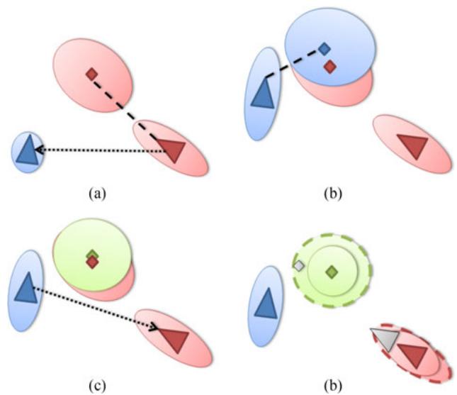
Fig. 6. Data incest in a SLAM context. Triangles represent vehicles and diamonds, landmarks. Ellipses are the corresponding uncertainties. (a) The red landmark is mapped by the red vehicle and is then sent to the blue one. (b) The blue landmark is mapped by the blue vehicle. The red landmark is the one previously received. (c) The green landmark is the fusion between the blue and red ones by the blue vehicle and sent to the red one. (d) The grey triangle is the true pose of the red vehicle (and similarly for the landmark). Dotted ellipses are the true uncertainties. Plain ones are those estimated after the fusion of the green landmark with the red one (data incest).
The first works on that matter come from the data fusion community where a task was split between several CPUs to speed up the computations. For instance, the multi-vehicle localization algorithm proposed by Nettleton et al. in [220] is derived from the advances in decentralized data fusion presented in [221] and [222]. We will focus here on the main design difficulties of such methods: data incest, data association and communication issues before discussing the main experimental results.
1) Data Incest: One common difficulty between the applications sharing information is data incest which is responsible for inconsistency by double-counting data in the estimation process. Decentralized SLAM (or decentralized localization as a whole) is particularly prone to this phenomenon as observations and maps are shared, relayed and fused by vehicles [223], [224]. The data incest phenomenon in a SLAM context is illustrated in Fig. 6. In this example, the red vehicle receives from the blue one a fused state already integrating its own map. As it does not know it, it will fuse this landmark within its map and thus double-count its own landmark and become overconfident (inconsistent). Keeping a track of what is exchanged is a possibility with a few vehicles but does not scale well with a large fleet.
To solve this problem in a SLAM context, Nettleton et al. in [220] proposed a dedicated network architecture to avoid double-counting. Only point-to-point communications are allowed thus forcing information to go through several nodes before reaching its target. In [225], an approach where submaps are only exchanged when closed is exposed. A topological global map puts all the submaps in a common frame. The main constraint comes from the fact that submaps cannot be updated and are only sent once on the network. The work of Vidal-Calleja et al. in [226] also proposes an extension of submap SLAM, and more specifically of the hierarchical approach introduced in [31]. Only the topological map is exchanged inside the fleet and a global metric map cannot be recovered on the fly. In [227], a multi-robot graph-based SLAM is introduced. The map of each vehicle is compressed and sent to the neighbors. A data cache filters out already received information. Similarly, in [228] and [229], a consensus is sought between neighbors so as to find the best map possible that avoids double-counting information. In [113], each vehicle state (pose and map) is stored separately from the others. Each vehicle can obtain a global map by fusing all the received states with its own. In [230], the Split Covariance Intersection Filter (SCIF), initiated by Julier et al. in [231], is applied to a multi-vehicle context. This filter is based on Covariance Intersection so as to produce consistent estimates even with unknown correlations between data.
2) Data Association: Data association in a multi-vehicle context can be extremely complicated as the relative positions between the vehicles are not necessarily known and the information that can be communicated is limited by the bandwidth. Some approaches have chosen to consider that the initial distance between the vehicles is known beforehand [220], [232]. Another possibility, introduced in [233], is to define a rendezvous towards which vehicles will converge to observe themselves directly.
Among the data association algorithms specifically designed for a multi-vehicle application, we can cite [234] in which each landmark is characterized by measures (distance and angle) to other close landmarks. Similar configurations of landmarks are then sought in maps from different vehicles. In [235], landmarks are grouped by 3 and a Delaunay triangulation is applied to obtain a unique map. The perimeters and areas of these triangles are given to a RANSAC algorithm in order to find the best correspondence between two map pieces coming from two different vehicles. In [236], the authors analyze the distribution of potential multi-vehicle correspondences. Inliers are assumed to produce the same transformation between two vehicles conversely to outliers. A clustering algorithm is used to find initial candidates that can then be further analyzed with more classical methods. The works of Li et al. [144], [145] solve the initial alignment of the maps from different vehicles using a low-cost GPS and a genetic algorithm in the restrained search space
3) Communication Issues: The bandwidth needs are often neglected in decentralized SLAM. For instance, in [225], submaps are directly sent. In [237], graphs (nodes comprise raw data) are exchanged, which is only suitable for small vehicle fleets. In [238], the authors propose to exchange maps only when vehicles can detect each other, which means that big amount of data will be sent punctually. Methods communicating only topological maps, like in [226] and [227], avoid this problem by providing very light maps.
The exchange strategy should also be able to cope with potential losses and delays. When not considered, a temporary saturation or failure can lead to information definitively lost [225], [237]. The algorithms built around interactions with neighbors are usually capable of identifying and asking for missing data [227]. Another possibility, described in [239], is the Lazy BeliefPropagation which integrates observations in a Particle Filter that does not depend on the temporal order in which data are added to the filter. Thus, missing or late information can still be integrated later without a problem. However, it is necessary to be able to identify missing values. More generally, all the approaches based on the inverse form of the Kalman Filter, namely the Information Filter, handle delay natively. Indeed, the update becomes additive and does not depend on any temporal order. It has become a common choice in the multi-vehicle community [234], [240], [241].
4) Experimental Results: The experiments carried out in the previously cited articles give a clear visibility on the potential deployment of such methods for autonomous driving. Indeed, most methods are only demonstrated in simulated experiments [220], [225], [227], [235], [239], [240]. The main reason is that addressing all the issues mentioned in this section in order to conduct real data experiments can be difficult as they are not all directly connected to the estimation problem. Some approaches have been demonstrated indoor in real time [233], [242]. In [226], the authors demonstrate an air/ground cooperation in outdoor environment. The map is built in a cooperative fashion with vision landmarks. The accuracy has not been measured. In [113], outdoor experiments with two or three vehicles are performed. The method relies on the exchange of visual landmarks. The accuracy oscillates between 50 cm and a few meters depending on the capacity of the vehicle to identify common landmarks. Finally, in [145], 2 vehicles equipped with laser merge their maps together in an outdoor experiment. The method is able to reach a 3-meter error on average.
This short survey of recent results shows that we are still far from generalizing the use of decentralized SLAM for autonomous driving. However, the communication means themselves continue to improve and bandwidth limitations might be less of a problem in the coming years. Still, large-scale demonstrations of the capabilities of decentralized SLAM are yet to be proven and applying the previously described approaches to autonomous driving is one of the upcoming challenges of SLAM.
## C. Discussion
This overview of multi-robot SLAM approaches has showed that the maturity of such methods for autonomous driving differs vastly depending on the way data are handled (in a centralized or decentralized fashion). Online centralized SLAM systems have been demonstrated on small-scale experiments with either a classic computer that serves as a hub to collect observations or with cloud processing. The extension from mobile robots to driverless cars raises the question of the bandwidth capacity that will be available in tomorrow’s cars but most importantly of the availability of an Internet connection in the vehicle. Completely offloading critical processing onto the cloud will probably not be safe enough. However, delegating the task of updating maps gathered from several vehicles in a reasonable amount of time is an interesting prospect. Real-time updates for map portions that might have changed could help driverless cars to adapt in a quicker way. Moreover, environmental conditions that have a low dynamicity could be alerted beforehand in order for the vehicle to anticipate by choosing more adapted features, etc. To attain this goal, large-scale experiments, involving a realistic number of vehicles, are necessary. It also means that a major prospect remains the design of software architectures able to cope with data flows and to properly segment updates. One key element to make online cloud-based methods viable is the choice of a map representation able to integrate all incoming information.
In that sense, fully decentralized methods share similar goals. The main difference comes from the fact that, by receiving the information from nearby cars, the ego-vehicle can select which information to integrate in its map. An interesting challenge thus becomes to establish criteria in order to evaluate the information gain that can bring maps coming from different vehicles with relation to the goal of the ego-vehicle (destination, energetic constraints, etc.). However, all the practical implications of decentralized methods are the first challenge to tackle. Contrary to cloud approaches, where processing power is less of a limit, the tractability of the final solution will also be an important factor to consider. Large-scale experiments are also an important milestone to reach in order to clearly exhibit the benefits of decentralized SLAM for autonomous vehicles.
Offline centralized methods might be the most mature for autonomous driving mainly because this challenge is very close to multisession SLAM. While future HAD maps may not provide all the needed information to reliably localize a vehicle in various conditions, probe cars might be a way to quickly gather enough data to build such maps. It is also an interesting perspective regarding the capacity of vehicles to detect long-term changes. Indeed, the agglomeration of different viewpoints on a situation should ease this process. Being able to limit the growth of these maps remains a blocking point. Finally, a considerable challenge is to build sufficiently robust software architectures to integrate and process all these data. The cost of such an infrastructure directs large-scale experiments with such methods towards industrial companies rather than small research teams.
## VI. LARGE-SCALE EXPERIMENTS FOR AUTONOMOUS VEHICLES
During the recent years, the scope of the experiments used to validate localization algorithms has broadened with the availability of large-scale data sets. Moreover, many research teams now have a dedicated platform to test, during many kilometers, their algorithms. In this section, we give an overview of the large-scale experiments that have involved fully autonomous vehicles. We will, of course, focus on the localization algorithms and the context in which they have been used.
The first large-scale experiments took place at the beginning of the 90’s and were mostly on highways [243], [244]. In both approaches, localization was performed using lane detection with vision sensors to laterally position the vehicle on the road. Lane detection algorithms have been the default localization system in autonomous driving demonstration for a long time as it is totally appropriate in a highway context. The DARPA Grand Challenge [245] with its 244-km race across the desert changed things with a new setting. In [246], a GPS is coupled with elevation maps built using laser scanners and a road-finding algorithm in order to avoid cliffs, rocks and the like. A similar approach is chosen by the winner of the challenge [247]. The GPS is coupled with an IMU and an algorithm to detect the road. In [248], a terrain reconstruction with lasers was also used. In mostly empty territories, the use of a GPS alone was sufficient for navigation. Obstacles and the difficult terrain added the necessity to build maps that can provide a safe corridor in which vehicles could evolve.
The DARPA Urban Challenge that followed focused on urban environments with a 97-km autonomy test in a city-like traffic [249]. It has to be noted that the environment was still sufficiently open for a Differential GPS to operate properly. The reliance on maps was more important this time. The Route Network Definition File (RNDF) format was specially designed for this challenge in order to furnish the topology and geometry of the road. Junior, the vehicle proposed by Stanford [250], used a GPS and the RNDF map to position the vehicle. The accuracy was improved with a laser system performing lane and curb detection. In [251], a visual lane detection algorithm combined with the RNDF was responsible for the vehicle localization. The authors pointed out the difficulty to have a reliable localization with a vision-only system because of environmental conditions like shadows, etc. The winner of this challenge [252] combined a GPS along with an IMU and the RNDF map. Localization was improved with a laser-based lane detection. The authors mention the necessity of prior road models for an efficient localization. Semantic information is also referred to as an important point in order to disambiguate situations.
Another interesting challenge conducted in 2011 is the Grand Cooperative Driving Challenge (GCDC) [253]. The idea was to evaluate how collaboration in platooning can help to reduce congestion. The winner of the GCDC challenge in 2011 [254] used a previously built map in which received positions of the other fleet members were matched and coupled with on-board radar detection. This showed that sharing simple localization information can still benefit autonomous driving by agreeing on speed or anticipating maneuvers.
A very large-scale experiment has been conducted by the VisLab team [255] with a 13,000-km trip from Italy to China. Technical details about the embedded technologies can be found in [256]. The localization was performed using a lane keeping algorithm (stereo and monocular) and a leader following system. A laser terrain mapping algorithm was also implemented for off-road driving but not used in this experiment. The leader following is an interesting possibility for autonomous driving if vehicles agree on their destination (or at least, a part of the trip). It still implies that one vehicle should be able to have a full localization system. For instance, cars with less expensive sensors could use platooning-like formations.
Automatic guidance of a vehicle was demonstrated in [257] for the Stadpilot project. This work can be seen as an update of the results of the Urban Challenge [249]. During a 15-km experiment on open roads, a combination of DGPS, IMU and lane keeping algorithm was used. Prior digital maps were also employed. Based on their experience in DARPA, the authors clearly indicate that GPS and IMU are not sufficient for autonomous driving in urban environments. An evolution of [255] was presented in [258]. In a 13-km experiment in different environments and real traffic, VisLab demonstrated the possibility of using lane or leader following based on vision, IMU and DGPS. An interesting aspect is that a map of the environment was used to trigger the appropriate perception module.
The V-Charge project aims at providing automated valet parking with close-to-market sensors. In [259], the authors evaluate their localization approach in a real-world scenario. First, the map is built using SURF keypoints extraction from fisheye cameras. Loop closures are defined manually and the map is optimized using global Bundle Adjustment. Localization is then performed against the known map still using SURF features. The algorithm is evaluated 0, 1 and 2 months after the map creation with a sufficient accuracy. However, the authors state that map update is needed over long periods of time to reflect changes. Another open question raised here but not addressed is the map portability between different vehicles. Still in the V-Charge project, [260] completed this system with height maps built from stereovision. A semantic map and a road graph were also needed to identify parking places and how to navigate between them.
Large-scale outdoor experiments with mobile robots have also been carried out in real-world environments. In [261], a robot traveled 20 km in crowded streets. The map was built beforehand with a graph-based laser SLAM. The on-the-fly localization was based on a particle filter and a GPS for initialization. The system was able to perform reinitialization when lost. The authors indicate that mobile obstacles masking the map were a source of localization losses. In [262], a robot traveled several times at different periods of the year a 1-km road. The map was built beforehand as well and the localization was based on road boundaries detected by laser and integrated inside an EKF. One of the problems cited by the authors is the recovery when the robot is lost and the GPS is not available. Also appearance changes, like leaves on the ground, proved to be difficult to handle. In [263], a 6-km experiment in pedestrian walkways is discussed. A 3D laser map of edges was built beforehand with 2D lasers. The localization system compared the map with the current observation to weight the particles of a particle filter. An important difficulty faced by the authors is the presence of glass windows that disturbed the localization system based on laser. They conclude by saying that 2D lasers are not sufficient for this kind of experiments.
Shuttle demonstrations in cities are also becoming more frequent as the mapping is confined to a dedicated area. In [264], the authors discuss the lessons learned after 1,500 km of a vision-guided shuttle in a private site. The experiments took place over 3 months and the localization was performed using a hierarchical Bundle Adjustment method over a previously built map. This approach could be used with either a front or a back camera. The main difficulties were the lightning conditions despite the use of front and back cameras. The dynamic range of vision sensors was not sufficient to handle day-time changes that were qualified by the authors as having a greater impact on the localization than the 3-month gap. The CityMobil2 project has cumulated 26,000 km in various cities for several months [265]. The localization differed depending on the experiments but was based on pre-built maps with laser or vision and GPS. The weather and the general reliability of the software had a significant impact on the results.
Already discussed before, Levinson et al. showed an update of the Stanford’s vehicle from the Urban Challenge in [266]. Ground maps were generated using precise GPS, IMU and a 64-layer 3D laser from multiple passages in an offline manner. The localization inside this map was then performed in realtime with a 2D histogram filter for a 10-cm accuracy on many kilometers. The approach of Ulm University is exposed in [267]. A map, composed of MSER features coming from vision and of a laser grid, is built beforehand and geo-referenced using a RTK-GPS. This map representation is light and allowed for a 10-cm accuracy on average during the 5-km test. Using both sensors for localization improved the results but the need of a highly-precise built-in-advance map is seen as a problem by the authors.
BMW, in [268], gives an interesting overview of their experience with autonomous driving over thousands of kilometers on public roads (highways). Their approach relies on lane marking using vision and laser, as well as odometry and a DGPS. Road boundaries were also detected using laser and radar. A highprecision map is needed for a proper localization. Their map integrates semantic and geometric information (lane models, connectivity, etc.) as well as localization data (lane marking and road boundary positions) with different layers. The difficulties presented by the authors were the necessity to remap from time to time the environment for a proper online exploitation. This process should be automated according to the authors. Largescale maps are also a concern and they should be broken down in submaps. The standardization of these maps is also an important aspect that needs to be addressed to be able to use probe cars and crowd-source the required information for digital maps.
Daimler experimented with their autonomous vehicle over 103 km in mixed environments (urban, highways, etc.) with close-to-market sensors [109]. Their system is a combination of vision, radar and accurate digital maps. The localization fuses lane detection with feature-based localization for a 20-cm accuracy on average. All the lanes and features were acquired during a first passage and fused in a UKF. Among the topics of importance cited by the authors, the scalability of the maps is crucial. Two other major aspects that need to be addressed for a commercial use are the reliance on an up-to-date digital map as well as its accuracy. For the authors, the sensor setup should be improved in order to be less dependent of the map.
Among the industrial works in autonomous driving, Waymo (formerly Google Car project) was a pioneer. The project started following the DARPA Urban Challenge on the foundation of the winner [252]. While the algorithms are not specifically known, the localization relies on dedicated 3D maps built beforehand and corrected by hand. The capacity of Google makes that solution viable and more than 40,000 km per week are said to be driven by Waymo. Even with these impressive results, the disengagements reports published each year [269], [270] indicate that drivers must occasionally take back the wheel due to software failures and in a more frequent manner in urban environments. Conversely to Google, Tesla’s strategy is to collect data from their own vehicles in order to improve the capabilities of their vehicles [271]. This method offers, by definition, less control on the quality of the produced outputs. Anyway the role of this philosophy on the localization is not known.
## VII. DISCUSSION AND CONCLUSION
In this survey, we have focused on the individual challenges that should be considered depending on the approach chosen. To conclude this paper, we will now discuss how some more general aspects could have an impact on the localization of autonomous vehicles.
During the 23rd ITS World Congress, a localization competition was proposed. Based on low-resolution voxel maps of above-the-ground objects and lanes furnished by HERE, participants were asked to propose an accurate localization algorithm. The competition ended with no winner as the targeted accuracy was not reached. It is not yet clear if HAD maps, that are going to be available in the coming years, will provide a strong enough prior knowledge for localization algorithms. Depending on the outcome, the community will surely adapt what kind of prior knowledge is used in SLAM. These maps are also intended to be used as part of the Local Dynamic Map (LDM) that gathers static and dynamic information to which SLAM could contribute. As such, standardization is needed [272].
An aspect that is not often discussed is sensor placement. It can have a tremendous impact on the performance of a localization system. For instance, a laser on the car roof is going to have a clear view on the infrastructure and avoid most of the mobile obstacles while one in the undercarriage might be affected by masked information. Similarly, the minimal set of sensors necessary for localization is not clearly defined yet (even if lasers and cameras seem to be favored). Such a definition should be made conjointly with the map representation that is going to serve as prior knowledge. Of course, this aspect is also tightly linked to the cost of those sensors. An interesting perspective in that sense is multi-modality where a map could be built by an expensive 3D laser but then exploited by a simple camera as proposed in [273]. Another interesting challenge is to build flexible architectures in which a decision system can choose what are the sensors, detectors or maps to favor depending on the context.
Context by itself is an important part of autonomous driving and its understanding would help place recognition algorithms or could even be directly integrated to make SLAM more robust. For now, most of the works carried out have concerned indoor localization. They have been initiated by Chatila et al. in [274] where semantic (object) maps are used for high-level decisionmaking. SLAM methods have since then been frequently considered for semantic map building. In [275] and [276], the authors take advantage of a 3D laser to identify the ceiling, the floor and objects. In [277], a conceptual space representation is proposed based on three different maps: metric (from a SLAM system), navigation (free space) and topological (connections between door-separated areas). The conceptual map allows the robot to have a semantic representation for rooms and objects that helps the interactions with users. In [278], the authors integrate well known objects inside a monocular SLAM. A similar approach is followed in SLAM++ [279] where objects are detected and optimized in a common localization framework. In these last two works, context and relations between objects are not directly used to reason upon. In that sense, semantic SLAM in outdoor environments is still a challenge that needs to be tackled.
However, semantic mapping from images alone is a field that has grown lately [280], [281]. Deep Convolutional Neural Networks have largely contributed to this trend and methods like SegNet [281] show impressive results. Their application in localization methods remains an open challenge but a direct use would be to remove moving, or temporally static, obstacles that can disturb the proper behavior of a SLAM algorithm. More generally, CNNs could change how place recognition is performed by using feature maps coming from these networks as in [142]. The impact and the use of CNNs for localization in autonomous driving will surely evolve in the coming years. A recent example like [282] shows that localization might not even be needed. In this paper, Nvidia demonstrates the possibility to directly learn the steering angle that should be applied from camera clues. Nevertheless, the scalability of such methods has yet to be demonstrated.
In the recent years, experiments have broadened their scope and autonomous driving for several kilometers and over long periods of time is more common. Shuttle experiments are also starting in various cities. Even though, in that case, SLAM approaches can use a previously built map without scalability issues, it is a good way to test them over long periods of time and confront them to the environment variability. In most roadmaps [283], the automation of transit systems is actually foreseen at a shorter term than other vehicles as it has the advantage to restrain the covered area.
Finally, the safety of localization algorithms is an important issue to consider. Multiple sources should be envisaged and strategies to safely switch among them must be designed. Taking into account the failures and their impacts on the localization system could help in creating degraded localization modes that ensure that a vehicle can reach a stopping spot safely.
## REFERENCES
[1] R. Smith and P. Cheeseman, “On the representation and estimation of spatial uncertainty,” Int. J. Robot. Res., vol. 5, no. 4, pp. 56–68, 1986.
[2] J. J. Leonard and H. Durrant-Whyte, “Simultaneous map building and localization for an autonomous mobile robot,” in Proc. IEEE/RSJ Int. Conf. Intell. Robots Syst., 1991, pp. 1442–1447.
[3] F. Dellaert, D. Fox, W. Burgard, and S. Thrun, “Monte Carlo localization for mobile robots,” in Proc. IEEE Int. Conf. Robot. Autom., 1999, vol. 2, pp. 1322–1328.
[4] T. Bailey and H. Durrant-Whyte, “Simultaneous localization and mapping (SLAM): Part II,” IEEE Robot. Autom. Mag., vol. 13, no. 3, pp. 108– 117, Sep. 2006.
[5] H. Durrant-Whyte and T. Bailey, “Simultaneous localization and mapping: Part I,” IEEE Robot. Autom. Mag., vol. 13, no. 2, pp. 99–110, Jun. 2006.
[6] S. Thrun, W. Burgard, and D. Fox, Probabilistic Robotics. Cambridge, MA, USA: MIT Press, 2005, ch. 3, pp. 279–484.
[7] C. Stachniss, J. J. Leonard, and S. Thrun, Springer Handbook ofRobotics. New York, NY, USA: Springer-Verlag, 2016, ch. 46, pp. 1153–1176.
[8] C. Cadena et al., “Past, present, and future of simultaneous localization and mapping: Toward the robust-perception age,” IEEE Trans. Robot., vol. 32, no. 6, pp. 1309–1332, Dec. 2016.
[9] C. Schmid, R. Mohr, and C. Bauckhage, “Evaluation of interest point detectors,” Int. J. Comput. Vis., vol. 37, no. 2, pp. 151–172, 2000.
[10] J. Civera, O. G. Grasa, A. J. Davison, and J. M. M. Montiel, “1-Point RANSAC for EKF filtering. Application to real-time structure from motion and visual odometry,” J. Fields Robot., vol. 27, no. 5, pp. 609–631, 2010.
[11] E. Mouragnon, M. Lhuillier, M. Dhome, F. Dekeyser, and P. Sayd, “Real time localization and 3D reconstruction,” in Proc. IEEE Comput. Soc. Conf. Comput. Vis. Pattern Recognit., 2006, pp. 363–370.
[12] R. E. Kalman, “A new approach to linear filtering and prediction problems,” J. Basic Eng., vol. 82, no. 1, pp. 35–45, 1960.
[13] M. W. M. G. Dissanayake, P. Newman, H. F. Durrant-Whyte, S. Clark, and M. Csorba, “An experimental and theoretical investigation into simultaneous localization and map building,” in Proc. 6th Int. Symp. Exp. Robot. VI, 2000, pp. 265–274.
[14] M. W. M. G. Dissanayake, P. Newman, H. F. Durrant-Whyte, S. Clark, and M. Csorba, “A solution to the simultaneous localization and map building (SLAM) problem,” IEEE Trans. Robot. Autom., vol. 17, no. 3, pp. 229–241, Jun. 2001.
[15] R. E. Kalman and R. S. Bucy, “New results in linear filtering and prediction theory,” J. Basic Eng., vol. 83, no. 3, pp. 95–108, 1961.
[16] S. J. Julier and J. K. Uhlmann, “A counter example to the theory of simultaneous localization and map building,” in Proc. IEEE Int. Conf. Robot. Autom., 2001, pp. 4238–4243.
[17] Y. Bar-Shalom, X. R. Li, and T. Kirubarajan, Estimation With Applications to Tracking and Navigation. Hoboken, NJ, USA: Wiley-Interscience, 2001.
[18] J. Guivant, E. Nebot, and S. Baiker, “Autonomous navigation and map building using laser range sensors in outdoor applications,” J. Robot. Syst., vol. 17, no. 10, pp. 565–583, 2000.
[19] J. Guivant and E. Nebot, “Optimization of the simultaneous localization and map building algorithm for real-time implementation,” IEEE Trans. Robot. Autom., vol. 17, no. 3, pp. 242–257, Jun. 2001.
[20] J. J. Leonard and H. J. S. Feder, “A computationally efficient method for large-scale concurrent mapping and localization,” in Proc. Int. Symp. Robot. Res., 2000, vol. 9, pp. 169–178.
[21] P. Newman and J. J. Leonard, “Pure range-only sub-sea SLAM,” in Proc. IEEE Int. Conf. Robot. Autom., 2003, vol. 2, pp. 1921–1926.
[22] P. Newman, J. Leonard, J. D. Tardos, and J. Neira, “Explore and return:´ Experimental validation of real-time concurrent mapping and localization,” in Proc. IEEE Int. Conf. Robot. Autom., 2002, vol. 2, pp. 1802– 1809.
[23] P. Newman, D. Cole, and K. Ho, “Outdoor SLAM using visual appearance and laser ranging,” in Proc. IEEE Int. Conf. Robot. Autom., 2006, pp. 1180–1187.
[24] A. J. Davison, “Real-time simultaneous localisation and mapping with a single camera,” in Proc. IEEE Int. Conf. Comput. Vis., 2003, pp. 1403– 1410.
[25] J. Montiel, J. Civera, and A. J. Davison, “Unified inverse depth parametrization for monocular SLAM,” in Proc. Robot., Sci. Syst., 2006, p. 8.
[26] G. Bresson, T. Feraud, R. Aufr´ ere, P. Checchin, and R. Chapuis, “Real\` time monocular SLAM with low memory requirements,” IEEE Trans. Intell. Transp. Syst., vol. 16, no. 4, pp. 1827–1839, Aug. 2015.
[27] S. B. Williams, G. Dissanayake, and H. Durrant-Whyte, “An efficient approach to the simultaneous localisation and mapping problem,” in Proc. IEEE Int. Conf. Robot. Autom., 2002, pp. 406–411.
[28] J. J. Leonard and P. Newman, “Consistent, convergent and constant-time SLAM,” in Proc. Int. Joint Conf. Artif. Intell., 2003, pp. 1143–1150.
[29] T. Bailey, “Mobile robot localisation and mapping in extensive outdoor environments,” Ph.D. dissertation, Aust. Centre Field Robot., Univ. Sydney, Sydney, NSW, Australia, 2002.
[30] M. Bosse, P. Newman, J. Leonard, M. Soika, W. Feiten, and S. Teller, “An atlas framework for scalable mapping,” in Proc. IEEE Int. Conf. Robot. Autom., 2003, vol. 2, pp. 1899–1906.
[31] C. Estrada, J. Neira, and J. D. Tardos, “Hierarchical SLAM: Real-time´ accurate mapping of large environments,” IEEE Trans. Robot., vol. 21, no. 4, pp. 588–596, Aug. 2005.
[32] P. Pinies and J. D. Tard´ os, “Large scale SLAM building conditionally´ independent local maps: Application to monocular vision,” IEEE Trans. Robot., vol. 24, no. 5, pp. 1094–1106, Oct. 2008.
[33] L. M. Paz, J. D. Tardos, and J. Neira, “Divide and Conquer: EKF ´ SLAM in O(n),” IEEE Trans. Robot., vol. 24, no. 5, pp. 1107–1120, Oct. 2008.
[34] J. L. Blanco, J. Gonzalez, and J.-A. Fern´ andez-Madrigal, “Subjective´ local maps for hybrid metric-topological SLAM,” Robot. Auton. Syst., vol. 57, no. 1, pp. 64–74, 2009.
[35] M. Chli and A. J. Davison, “Automatically and efficiently inferring the hierarchical structure of visual maps,” in Proc. IEEE Int. Conf. Robot. Autom., 2009, pp. 387–394.
[36] S. J. Julier and J. K. Uhlmann, “New extension of the Kalman filter to nonlinear systems,” in Proc. AeroSense, 1997, pp. 182–193.
[37] E. A. Wan and R. V. D. Merwe, “The unscented Kalman filter for nonlinear estimation,” in Proc. Adapt. Syst. Signal Process., Commun. Control Symp., 2000, pp. 153–158.
[38] S. J. Julier and J. K. Uhlmann, “Unscented filtering and nonlinear estimation,” Proc. IEEE, vol. 92, no. 3, pp. 401–422, Mar. 2004.
[39] D. Checklov, M. Pupilli, W. Mayol-Cuevas, and A. Calway, “Real-time and robust monocular SLAM using predictive multi-resolution descriptors,” Adv. Visual Comput., vol. 4292, pp. 276–285, 2006.
[40] P. S. Maybeck, Stochastic Models, Estimation and Control. Amsterdam, The Netherlands: Elsevier, 1982.
[41] Y. Liu and S. Thrun, “Results for outdoor-SLAM using sparse extended information filters,” in Proc. IEEE Int. Conf. Robot. Autom., 2003, vol. 1, pp. 1227–1233.
[42] S. Thrun, Y. Liu, D. Koller, A. Y. Ng, Z. Ghahramani, and H. Durrant-Whyte, “Simultaneous localization and mapping with sparse extended information filters,” Int. J. Robot. Res., vol. 23, no. 7/8, pp. 693–716, 2004.
[43] R. Eustice, M. Walter, and J. J. Leonard, “Sparse extended information filters: Insights into sparsification,” in Proc. IEEE/RSJ Int. Conf. Intell. Robots Syst., 2005, pp. 3281–3288.
[44] I. Mahon, S. B. Williams, O. Pizarro, and M. Johnson-Roberson, “Efficient view-based SLAM using visual loop closures,” IEEE Trans. Robot., vol. 24, no. 5, pp. 1002–1014, Oct. 2008.
[45] M. R. Walter, R. M. Eustice, and J. J. Leonard, “Exactly sparse extended information filters for feature-based SLAM,” Int. J. Robot. Res., vol. 26, no. 4, pp. 335–359, 2007.
[46] J.-S. Gutmann, E. E. nad Philip Fong, and M. E. Munich, “A constanttime algorithm for vector field SLAM using an exactly sparse extended information filter,” in Robotics: Science and Systems. Cambridge, MA, USA: MIT Press, 2010.
[47] A. Eliazar and R. Parr, “DP-SLAM: Fast, robust simultaneous localization and mapping without predetermined landmarks,” in Proc. Int. Joint Conf. Artif. Intell., 2003, vol. 3, pp. 1135–1142.
[48] A. Eliazar and R. Parr, “DP-SLAM 2.0,” in Proc. IEEE Int. Conf. Robot. Autom., 2004, pp. 1314–1320.
[49] M. Montemerlo, S. Thrun, D. Koller, and B. Wegbreit, “FastSLAM: A factored solution to the simultaneous localization and mapping problem,” in Proc. AAAI/IAAI Nat. Conf. Artif. Intell., 2002, pp. 593–598.
[50] K. P. Murphy, “Bayesian map learning in dynamic environments,” in Proc. Neural Inf. Process. Syst., 1999, pp. 1015–1021.
[51] S. Thrun, W. Burgard, and D. Fox, “A real-time algorithm for mobile robot mapping with applications to multi-robot and 3D mapping,” in Proc. IEEE Int. Conf. Robot. Autom., 2000, vol. 1, pp. 321–328.
[52] E. Eade and T. Drummond, “Scalable monocular SLAM,” in Proc. IEEE Comput. Soc. Conf. Comput. Vis. Pattern Recognit., 2006, vol. 1, pp. 469–476.
[53] T. Bailey, J. Nieto, and E. Nebot, “Consistency of the FastSLAM algorithm,” in Proc. IEEE Int. Conf. Robot. Autom., 2006, pp. 424–429.
[54] M. Mohan and K. K. Madhava, “Mapping large scale environments by combining particle filter and information filter,” in Proc. Int. Conf. Control, Autom., Robot. Vis., 2010, pp. 1000–1005.
[55] D. Hahnel, W. Burgard, D. Fox, and S. Thrun, “An efficient FastSLAM algorithm for generating maps of large-scale cyclic environments from raw laser range measurements,” in Proc. IEEE/RSJ Int. Conf. Intell. Robots Syst., 2003, vol. 1, pp. 206–211.
[56] T. Reineking and J. Clemens, “Evidential FastSLAM for grid mapping,” in Proc. 16th Int. Conf. Inf. Fusion, 2013, pp. 789–796.
[57] H. P. Moravec, “Sensor fusion in certainty grids for mobile robots,” AI Mag., vol. 9, no. 2, pp. 61–74, 1988.
[58] A. Elfes, “Using occupancy grids for mobile robot perception and navigation,” Computer, vol. 6, no. 22, pp. 46–57, 1989.
[59] Z. Alsayed, G. Bresson, F. Nashashibi, and A. Verroust-Blondet, “PML-SLAM: A solution for localization in large-scale urban environments,” in Proc. IEEE/RSJ Int. Conf. Intell. Robots Syst. Workshop Perception Navig. Auton. Veh. Human Environ., 2015, pp. 13–18.
[60] G. Trehard, Z. Alsayed, E. Pollard, B. Bradai, and F. Nashashibi, “Credibilist simultaneous localization and mapping with a LIDAR,” in Proc. IEEE/RSJ Int. Conf. Intell. Robots Syst., 2014, pp. 2699–2706.
[61] R. Rouveure, P. Faure, and M. Monod, “Radar-based SLAM without odometric sensor,” in Proc. Robot. 2010, Int. Workshop Mobile Robot. Environ./Agriculture, 2010, p. 9.
[62] D. Vivet, P. Checchin, and R. Chapuis, “Localization and mapping using only a rotating FMCW radar sensor,” Sensors, vol. 13, pp. 4527–4552, 2013.
[63] E. Jose and M. D. Adams, “An augmented state SLAM formulation for multiple line-of-sight features with millimetre wave RADAR,” in Proc. IEEE/RSJ Int. Conf. Intell. Robots Syst., 2005, pp. 3087–3092.
[64] B. Triggs, P. F. McLauchlan, R. I. Hartley, and A. W. Fitzgibbon, “Bundle adjustment: A modern synthesis,” in Vision Algorithms: Theory and Practice. New York, NY, USA: Springer-Verlag, 2000, pp. 298–372.
[65] W. Press, S. Keukolsky, W. Vettering, and B. Flannery, “Levenberg-Marquardt method,” Numerical Recipes in C: The Art of Scientific Computation. Cambridge, U.K.: Cambridge Univ. Press, 1992, pp. 542–547.
[66] H.-Y. Shum, Q. Ke, and Z. Zhang, “Efficient bundle adjustment with virtual key Frames: A hierarchical approach to multi-frame structure from motion,” in Proc. IEEE Comput. Soc. Conf. Comput. Vis. Pattern Recognit., 1999, p. 543.
[67] R. Hartley and A. Zisserman, Multiple View Geometry in Computer Vision. Cambridge, U.K.: Cambridge Univ. Press, 2000, ch. 18, pp. 434–457.
[68] E. Royer, M. Lhuillier, M. Dhome, and T. Chateau, “Localization in urban environments: Monocular vision compared to a differential GPS sensor,” in Proc. IEEE Comput. Soc.Conf. Comput. Vis. Pattern Recognit., 2005, pp. 114–121.
[69] D. Steedly and I. Essa, “Propagation of innovative information in nonlinear least-squres structure from motion,” in Proc. IEEE Int. Conf. Comput. Vis., 2001, pp. 223–229.
[70] Z. Zhang and Y. Shan, “Incremental motion estimation through modified bundle adjustment,” in Proc. Int. Conf. Image Process., 2003, pp. 343– 346.
[71] D. Nister, O. Naroditsky, and J. Bergen, “Visual odometry for ground ´ vehicle applications,” J. Fields Robot., vol. 23, no. 1, pp. 3–20, 2006.
[72] M. A. Fischler and R. C. Bolles, “Random sample consensus: A paradigm for model fitting with applications to image analysis and automated cartography,” Commun. ACM, vol. 24, no. 6, pp. 381–395, 1981.
[73] J. Michot, A. Bartoli, and F. Gaspard, “Bi-objective bundle adjustmen with application to multi-sensor SLAM,” in Proc. 5th Int. Symp. 3D Data Process., Vis. Transmiss., 2010, p. 9.
[74] K. Konolige and M. Agrawal, “FrameSLAM: From bundle adjustment to real-time visual mapping,” IEEE Trans. Robot., vol. 24, no. 5, pp. 1066– 1077, Oct. 2008.
[75] S. Thrun and J. J. Leonard, “Simultaneous localization and mapping,” in Springer Handbook of Robotics. New York, NY, USA: Springer-Verlag, 2008, pp. 871–889.
[76] G. Grisetti, S. Grzonka, C. Stachniss, P. Pfaff, and W. Burgard, “Efficient estimation of accurate maximum likelihood maps in 3D,” in Proc. IEEE/RSJ Int. Conf. Intell. Robots Syst., 2007, pp. 3472–3478.
[77] G. Grisetti, R. Kummerle, C. Stachniss, U. Frese, and C. Hertzberg, “Hierarchical optimization on manifolds for online 2D and 3D mapping,” in Proc. IEEE Int. Conf. Robot. Autom., 2010, pp. 273–278.
[78] R. Kummerle, G. Grisetti, H. Strasdat, K. Konolige, and W. Burgard, “g2o: A general framework for graph optimization,” in Proc. IEEE Int. Conf. Robot. Autom., 2011, pp. 3607–3613.
[79] G. Dubbelman and B. Browning, “Closed-form online pose-chain SLAM,” in Proc. IEEE Int. Conf. Robot. Autom., 2013, pp. 5190–5197.
[80] U. Frese and L. Schroder, “Closing a million-landmarks loop,” in Proc. IEEE/RSJ Int. Conf. Intell. Robots Syst., 2006, pp. 5032–5039.
[81] M. Kaess, A. Ranganathan, and F. Dellaert, “iSAM: Incremental smoothing and mapping,” IEEE Trans. Robot., vol. 24, no. 6, pp. 1365–1378, Dec. 2008.
[82] M. Kaess and F. Dellaert, “Covariance recovery from a square root information matrix for data association,” Robot. Auton. Syst., vol. 57, no. 12, pp. 1198–1210, 2009.
[83] H. Strasdat, J. M. M. Montiel, and A. J. Davison, “Real-time monocular SLAM: Why filter?” in Proc. IEEE Int. Conf. Robot. Autom., 2010, pp. 2657–2664.
[84] H. Strasdat, J. M. M. Montiel, and A. J. Davison, “Visual SLAM: Why filter?” Image Vis. Comput., vol. 30, no. 2, pp. 65–77, 2012.
[85] J. Aulinas, Y. Petillot, J. Salvi, and X. Llado, “The SLAM problem: ´ A survey,” in Proc. 11th Int. Conf. Catalan Assoc. Artif. Intell., 2008, pp. 363–371.
[86] G. Dissanayake, S. Huang, Z. Wang, and R. Ranasinghe, “A review of recent developments in simultaneous localization and mapping,” in Proc. IEEE 6th Int. Conf. Ind. Inf. Syst., 2011, pp. 477–482.
[87] S. Huang and G. Dissanayake, “A critique of current developments in simultaneous localization and mapping,” Int. J. Adv. Robot. Syst., vol. 13, no. 5, pp. 1–13, 2016.
[88] Z. Chen, J. Samarabandu, and R. Rodrigo, “Recent advances in simultaneous localization and map-building using computer vision,” Adv. Robot., vol. 21, no. 3/4, pp. 233–265, 2007.
[89] D. Scaramuzza and F. Fraundorfer, “Visual odometry: Part I: The first 30 years and fundamentals,” IEEE Robot. Autom. Mag., vol. 18, no. 4, pp. 80–92, Dec. 2011.
[90] F. Fraundorfer and D. Scaramuzza, “Visual odometry: Part II: Matching, robuRobust, optimization, and applications,” IEEE Robot. Autom. Mag., vol. 19, no. 2, pp. 78–90, Jun. 2012.
[91] J. Fuentes-Pacheco, J. Ruiz-Ascencio, and J. M. Rendon-Mancha, “Vi-´ sual simultaneous localization and mapping: A survey,” Artif. Intell. Rev., vol. 43, no. 1, pp. 55–81, 2012.
[92] G. Ros, A. D. Sappa, D. Ponsa, and A. M. Lopez, “Visual SLAM for driverless cars: A brief survey,” in Proc. IEEE Intell. Veh. Symp. Workshops, 2012, pp. 1–6.
[93] S. Lowry et al., “Visual place recognition: A survey,” IEEE Trans. Robot., vol. 32, no. 1, pp. 1–19, Feb. 2016.
[94] S. Saeedi, M. Trentini, M. Seto, and H. Li, “Multiple-robot simultaneous localization and mapping: A review,” J. Field Robot., vol. 33, no. 1, pp. 3–46, 2016.
[95] A. Bonarini, W. Burgard, G. Fontana, M. Matteucci, D. G. Sorrenti, and J. D. Tardos, “RAWSEEDS: Robotics advancement through web-´ publishing of sensorial and elaborated extensive data sets,” in Proc. IEEE/RSJ Int. Conf. Intell. Robots Syst. Workshop Benchmarks in Robot. Res., 2006, p. 5.
[96] M. Smith, I. Baldwin, W. Churchill, R. Paul, and P. Newman, “The new college vision and laser data set,” Int. J. Robot. Res., vol. 28, no. 5, pp. 595–599, 2009.
[97] A. Geiger, P. Lenz, and R. Urtasun, “Are we ready for autonomous driving? The KITTI vision benchmark suite,” in Proc. IEEE Conf. Comput. Vis. Pattern Recognit., 2012, pp. 3354–3361.
[98] J.-L. Blanco-Claraco, F.-A. Moreno-Duenas, and J. Gonzalez-Jim´ enez,´ “The Malaga Urban dataset: High-rate stereo and lidars in a realistic urban scenario,” Int. J. Robot. Res., vol. 33, no. 2, pp. 207–214, 2014.
[99] M. Cummins and P. Newman, “FAB-MAP: Probabilistic localization and mapping in the space of appearance,” Int. J. Robot. Res., vol. 27, no. 6, pp. 647–665, 2008.
[100] J.-L. Blanco, F.-A. Moreno, and J. Gonzalez, “A collection of outdoor robotic datasets with centimeter-accuracy ground truth,” Auton. Robots, vol. 27, no. 4, pp. 327–351, 2009.
[101] A. S. Huang et al., “A high-rate, heterogeneous data set from the DARPA urban challenge,” Int. J. Robot. Res., vol. 29, no. 13, pp. 1595–1601, 2010.
[102] T. Peynot, S. Scheding, and S. Terho, “The marulan data sets: Multisensor perception in natural environment with challenging conditions,” Int.J. Robot. Res., vol. 29, no. 13, pp. 1602–1607, 2010.
[103] A. Geiger, J. Ziegler, and C. Stiller, “StereoScan: Dense 3d reconstruction in real-time,” in Proc. IEEE Intell. Veh. Symp., 2011, pp. 963–968.
[104] G. Pandey, J. R. McBride, and R. M. Eustice, “Ford campus vision and lidar data set,” Int. J. Robot. Res., vol. 30, no. 13, pp. 1543–1552, 2011.
[105] J. Zhang and S. Singh, “Visual-Lidar odometry and mapping: Low-drift, robust, and fast,” in Proc. IEEE Int. Conf. Robot. Autom., 2015, pp. 2174– 2181.
[106] I. Cvisiˇ c and I. Petrovi´ c, “Stereo odometry based on careful feature´ selection and tracking,” in Proc. 2015 Eur. Conf. Mobile Robot., 2015, pp. 1–6.
[107] M. Buczko and V. Willert, “How to distinguish inliers from outliers in visual odometry for high-speed automotive applications,” in Proc. IEEE Intell. Veh. Symp., 2016, pp. 478–483.
[108] M. Persson, T. Piccini, M. Felsberg, and R. Mester, “Robust stereo visual odometry from monocular techniques,” in Proc. IEEE Intell. Veh. Symp., 2015, pp. 686–691.
[109] J. Ziegler et al., “Making bertha drive: An autonomous journey on a historic route,” IEEE Intell. Transp. Syst. Mag., vol. 6, no. 2, pp. 8–20, Summer 2014.
[110] S. Huang and G. Dissanayake, “Convergence and consistency analysis for extended kalman filter based SLAM,” IEEE Trans. Robot., vol. 23, no. 5, pp. 1036–1049, Oct. 2007.
[111] T. Bailey, J. Nieto, J. Guivant, M. Stevens, and E. Nebot, “Consistency of the EKF-SLAM algorithm,” in Proc. IEEE/RSJ Int. Conf. Intell. Robots Syst., 2006, pp. 3562–3568.
[112] U. Frese, “A Discussion of simultaneous localization and mapping,” Auton. Robots, vol. 20, no. 1, pp. 25–42, 2006.
[113] G. Bresson, R. Aufrere, and R. Chapuis, “A general consistent decentral-\` ized SLAM solution,” Robot. Auton. Syst., no. 74, pp. 128–147, 2015.
[114] S. Huang, Y. Lai, U. Frese, and G. Dissanayake, “How far is SLAM from a linear least squares problem?” in Proc. IEEE/RSJ Int. Conf. Intell. Robots Syst., 2010, pp. 3011–3016.
[115] J. A. Castellanos, J. Neira, and J. D. Tardos, “Limits to the consistency of ´ EKF-Based SLAM,” in Proc. 5th IFAC Symp. Intell. Auton. Veh., 2004, pp. 716–721.
[116] J. A. Castellanos, R. Martinez-Cantin, J. D. Tardos, and J. Neira, “Robo-´ centric map joining: Improving the consistency of EKF-SLAM,” Robot. Auton. Syst., vol. 55, no. 1, pp. 21–29, 2007.
[117] J. Civera, O. G. Grasa, A. J. Davison, and J. M. M. Montiel, “1-Point RANSAC for EKF-based structure from motion,” in Proc. IEEE/RSJ Int. Conf. Intell. Robot Syst., 2009, pp. 3498–3504.
[118] B. P. Williams and I. D. Reid, “On combining visual SLAM and visual odometry,” in Proc. IEEE Int. Conf. Robot.Autom., 2010, pp. 3494–3500.
[119] T.-D. Vu, “Vehicle perception: Localization, mapping with detection, classification and tracking of moving objects,” Ph.D. dissertation, Inst. Nat. Polytechnique de Grenoble-INPG, Grenoble, France, 2009.
[120] C.-C. Wang, C. Thorpe, and A. Suppe, “Ladar-based detection and tracking of moving objects from a ground vehicle at high speeds,” in Proc. IEEE Intell. Veh. Symp., 2003, pp. 416–421.
[121] C.-C. Wang, C. Thorpe, and S. Thrun, “Online simultaneous localization and mapping with detection and tracking of moving objects: Theory and results from a ground vehicle in crowded urban areas,” in Proc. IEEE Int. Conf. Robot. Autom., 2003, pp. 842–849.
[122] S. I. Roumeliotis, G. S. Sukhatme, and G. A. Bekey, “Sensor fault detection and identification in a mobile robot,” in Proc. IEEE/RSJ Int. Conf. Intell. Robots Syst., 1998, pp. 1383–1388.
[123] P. Goel, G. Dedeoglu, S. I. Roumeliotis, and G. S. Sukhatme, “Fault detection and identification in a mobile robot using multiple model estimation and neural network,” in Proc. IEEE Int. Conf. Robot. Autom., 2000, pp. 2302–2309.
[124] P. Sundvall and P. Jensfelt, “Fault detection for mobile robots using redundant positioning systems,” in Proc. IEEE Int. Conf. Robot. Autom., 2006, pp. 3781–3786.
[125] Y. Morales, E. Takeuchi, and T. Tsubouchi, “Vehicle localization in outdoor woodland environments with sensor fault detection,” in Proc. IEEE Int. Conf. Robot. Autom., 2008, pp. 449–454.
[126] A. Jabbari, R. Jedermann, and W. Lang, “Application of computational intelligence for sensor fault detection and isolation,” World Acad. Sci., Eng. Technol., vol. 33, pp. 265–270, 2007.
[127] J. Engel, V. Koltun, and D. Cremers, “Direct sparse odometry,” IEEE Trans. Pattern Anal. Mach. Intell., vol. PP. no. 99, pp. 1–1, 2017, 10.1109/TPAMI.2017.2658577.
[128] R. C. Luo, C.-C. Yih, and K. L. Su, “Multisensor fusion and integration: Approaches, applications, and future research directions,” IEEE Sensors J., vol. 2, no. 2, pp. 107–119, Apr. 2002.
[129] J. A. Castellanos, J. Neira, and J. D. Tardos, “Multisensor fusion for´ simultaneous localization and map building,” IEEE Trans. Robot.Autom., vol. 17, no. 6, pp. 908–914, Dec. 2001.
[130] L. Wei, C. Cappelle, and Y. Ruichek, “Camera/laser/GPS fusion method for vehicle positioning under extended NIS-based sensor validation,” IEEE Trans. Instrum. Meas., vol. 62, no. 11, pp. 3110–3122, Nov. 2013.
[131] B. Williams, M. Cummins, J. Neira, P. Newman, I. Reid, and J. Tardos,´ “A comparison of loop closing techniques in monocular SLAM,” Robot. Auton. Syst., vol. 57, no. 12, pp. 1188–1197, 2009.
[132] E. Eade and T. Drummond, “Unified loop closing and recovery for real time monocular SLAM,” in Proc. Brit. Mach. Vis. Conf., 2008, pp. 6.1– 6.10.
[133] L. A. Clemente, A. J. Davison, I. D. Reid, J. Neira, and J. D. Tardos, ´ “Mapping large loops with a single hand-held camera,” in Proc. Robot., Science and Syst., 2007, p. 8.
[134] B. Williams, M. Cummins, J. Neira, P. Newman, I. Reid, and J. Tardos,´ “An image-to-map loop closing method for monocular SLAM,” in Proc. IEEE/RSJ Int. Conf. Intell. Robots Syst., 2008, pp. 2053–2059.
[135] J. Sivic and A. Zisserman, “Efficient visual search of videos cast as text retrieval,” IEEE Trans. Pattern Anal. Mach. Intell., vol. 31, no. 4, pp. 591–606, Apr. 2009.
[136] D. G. Lowe, “Distinctive image features from scale-invariant keypoints,” Int. J. Comput. Vis., vol. 60, no. 2, pp. 91–110, 2004.
[137] M. Cummins and P. Newman, “Appearance-only SLAM at large scale with FAB-MAP 2.0,” Int. J. Robot. Res., vol. 30, no. 9, pp. 1100–1123, 2011.
[138] A. Kawewong, N. Tongprasit, S. Tangruamsub, and O. Hasegawa, “Online and incremental appearance-based SLAM in highly dynamic environments,” Int. J. Robot. Res., vol. 30, no. 1, pp. 33–55, 2010.
[139] M. J. Milford and G. F. Wyeth, “SeqSLAM: Visual route-based navigation for sunny summer days and stormy winter nights,” in Proc. IEEE Int. Conf. Robot. Autom., 2012, pp. 1643–1649.
[140] E. Pepperell, P. Corke, and M. Milford, “Routed roads: Probabilistic vision-based place recognition for changing conditions, split street and varied viewpoints,” Int. J. Robot. Res., vol. 35, pp. 1057–1179, 2016.
[141] T. Naseer, L. Spinello, W. Burgard, and C. Stachniss, “Robust visual robot localization across seasons using network flows,” in Proc. AAAI Conf. Artif. Intell., 2014, pp. 2564–2570.
[142] T. Naseer, M. Ruhnke, C. Stachniss, L. Spinello, and W. Burgard, “Robust visual SLAM across seasons,” in Proc. IEEE/RSJ Int. Conf. Intell. Robots Syst., 2015, pp. 2529–2535.
[143] J. Neira, J. D. Tardos, and J. A. Castellanos, “Linear time vehicle relo-´ cation in SLAM,” in Proc. IEEE Int. Conf. Robot. Autom., 2003, vol. 1, pp. 427–433.
[144] H. Li and F. Nashashibi, “A new method for occupancy grid maps merging: Application to multi-vehicle cooperative local mapping and moving object detection in outdoor environment,” in Proc. Int. Conf. Control, Autom., Robot. Vis., 2012, pp. 632–637.
[145] H. Li and F. Nashashibi, “Multi-vehicle cooperative localization using indirect vehicle-to-vehicle relative pose estimation,” in Proc. IEEE Int. Conf. Veh. Electron. Safety, 2012, pp. 267–272.
[146] J. Neira and J. D. Tardos, “Data association in stochastic mapping using´ the joint compatibility Test,” IEEE Trans. Robot. Autom., vol. 17, no. 6, pp. 890–897, Dec. 2002.
[147] J. Xie, F. Nashashibi, M. Parent, and O. G. Favrot, “A real-time robust global localization for autonomous mobile robots in large environments,” in Proc. Int. Conf. Control, Autom., Robot. Vis., 2010, pp. 1397–1402.
[148] P. Newman et al., “Navigating, recognising and describing urban spaces with vision and laser,” Int. J. Robot. Res., vol. 28, no. 11-12, pp. 1406– 1433, 2009.
[149] P. Besl and N. McKay, “Method for registration of 3-D shapes,” IEEE Trans. Pattern Anal. Mach. Intell., vol. 14, no. 2, pp. 239–256, Feb. 2002.
[150] J. McDonald, M. Kaess, C. Cadena, J. Neira, and J. J. Leonard, “6-DOF multi-session visual SLAM using anchor nodes,” in Proc. Eur. Conf. Mobile Robot., 2011, pp. 69–76.
[151] A. Martinelli, N. Tomatis, and R. Siegwart, “Some results on SLAM and the closing the loop problem,” in Proc. IEEE/RSJ Int. Conf. Intell. Robots Syst., 2005, pp. 2917–2922.
[152] D. M. Cole and P. M. Newman, “Using laser range data for 3D SLAM in outdoor environments,” in Proc. IEEE Int. Conf. Robot. Autom., 2006, pp. 1556–1563.
[153] G. Bresson, M.-C. Rahal, D. Gruyer, M. Revilloud, and Z. Alsayed, “A cooperative fusion architecture for robust localization: Application to autonomous driving,” in Proc. IEEE 19th Int. Conf. Intell. Transp. Syst., 2016, pp. 859–866.
[154] H. Johannsson, M. Kaess, M. Fallon, and J. J. Leonard, “Temporally scalable visual SLAM using a reduced pose graph,” in Proc. IEEE Int. Conf. Robot. Autom., 2013, pp. 54–61.
[155] T. Feraud, P. Checchin, R. Aufr´ ere, and R. Chapuis, “Communicating\` vehicles in convoy and monocular vision-based localization,” in Proc. 7th Symp. Intell. Auton. Veh., 2010, vol. 7, pp. 73–78.
[156] J. P. Lewis, “Fast normalized cross-correlation,” in Proc. Vis. Interface, 1995, pp. 120–123.
[157] E. Menegatti, T. Maeda, and H. Ishiguro, “Image-based memory for robot navigation using properties of omnidirectional images,” Robot. Auton. Syst., vol. 47, no. 4, pp. 251–267, 2004.
[158] A. Remazeilles, F. Chaumette, and P. Gros, “Robot motion control from a visual memory,” in Proc. IEEE Int. Conf. Robot. Autom., 2004, pp. 4695– 4700.
[159] M. Jogan and A. Leonardis, “Robust localization using panoramic viewbased recognition,” in Proc. 15th Int. Conf. Pattern Recognit., 2000, pp. 136–139.
[160] O. Vysotka and C. Stachniss, “Lazy data association for image sequences matching under substantial appearance change,” IEEE Robot. Autom. Lett., vol. 1, no. 1, pp. 213–220, Jan. 2016.
[161] A. Walcott-Bryant, M. Kaess, H. Johannsson, and J. J. Leonard, “Dynamic pose graph SLAM: Long-term mapping in low dynamic environments,” in Proc. IEEE/RSJ Int. Conf. Intell. Robots Syst., 2012, pp. 1871–1878.
[162] K. Konolige and J. Bowman, “Towards lifelong visual maps,” in Proc. IEEE/RSJ Int. Conf. Intell. Robots Syst., 2009, pp. 1156–1163.
[163] W. Churchill and P. Newman, “Practice makes perfect? managing and leveraging visual experiences for lifelong navigation,” in Proc. IEEE Int. Conf. Robot. Autom., 2012, pp. 4525–4532.
[164] C. Linegar, W. Churchill, and P. Newman, “Made to measure: Bespoke landmarks for 24-hour, all-weather localisation with a camera,” in Proc. IEEE Int. Conf. Robot. Autom., 2016, pp. 787–794.
[165] A. Kendall, M. Grimes, and R. Cipolla, “PoseNet: A convolutional network for real-time 6-DOF camera relocalization,” in Proc. IEEE Int. Conf. Comput. Vis., 2015, pp. 2938–2946.
[166] P. Muhlfellner, M. Brki, M. Bosse, W. Derendarz, R. Philippsen, and P. Furgale, “Summary maps for lifelong visual localization,” J. Field Robot., vol. 33, no. 5, pp. 561–590, 2015.
[167] H. Grimmett et al., “Integrating metric and semantic maps for visiononly automated parking,” in Proc. IEEE Int. Conf. Robot. Autom., 2015, pp. 2159–2166.
[168] P. Biber and T. Duckett, “Experimental analysis of sample-based maps for long-term SLAM,” Int. J. Robot. Res., vol. 28, no. 1, pp. 20–33, 2009.
[169] A. I. Comport, M. Meilland, and P. Rives, “An asymmetric real-time dense visual localisation and mapping system,” in Proc. IEEE Int. Conf. Comput. Vis. Workshops, 2011, pp. 700–703.
[170] M. Meilland, A. I. Comport, and P. Rives, “Dense visual mapping of large scale environments for real-time localisation,” in Proc. IEEE/RSJ Int. Conf. Intell. Robots Syst., 2011, pp. 4242–4248.
[171] P. Furgale and T. D. Barfoot, “Visual teach and repeat for long-range rover autonomy,” J. Field Robot., vol. 27, no. 5, pp. 537–560, 2010.
[172] E. Royer, M. Lhuillier, M. Dhome, and J.-M. Lavest, “Monocular vision for mobile robot localization and autonomous navigation,” Int. J. Comput. Vis., vol. 74, no. 3, pp. 237–260, 2007.
[173] H. Lategahn and C. Stiller, “City GPS using stereo vision,” in Proc. IEEE Int. Conf. Veh. Electron. Safety, 2012, pp. 1–6.
[174] H. Badino, D. Huber, and T. Kanade, “Real-time topometric localization,” in Proc. IEEE Int. Conf. Robot. Autom., 2012, pp. 1635–1642.
[175] J. Matas, O. Chum, M. Urban, and T. Pajdla, “Robust wide-baseline stereo from maximally stable extremal regions,” Image Vis. Comput., vol. 22, no. 10, pp. 761–767, 2004.
[176] H. Deusch, J. Wiest, S. Reuter, D. Nuss, M. Fritzsche, and K. Dietmayer, “Multi-sensor self-localization based on maximally stable extremal regions,” in Proc. IEEE Intell. Veh. Symp., 2014, pp. 555–560.
[177] J. Levinson, M. Montemerlo, and S. Thrun, “Map-based precision vehicle localization in urban environments,” in Robotics: Science and Systems, vol. 4. Cambridge, MA, USA: MIT Press, 2007.
[178] J. Levinson and S. Thrun, “Robust vehicle localization in urban environments using probabilistic maps,” in Proc. IEEE Int. Conf. Robot. Autom., 2010, pp. 4372–4378.
[179] A. Napier and P. Newman, “Generation and exploitation of local orthographic imagery for road vehicle localisation,” in Proc. IEEE Intell. Veh. Symp., 2012, pp. 590–596.
[180] D. Betaille and R. Toledo-Moreo, “Creating enhanced maps for lanelevel vehicle navigation,” IEEE Trans. Intell. Transp. Syst., vol. 11, no. 4, pp. 786–798, Dec. 2010.
[181] R. Toledo-Moreo, D. Betaille, and F. Peyret, “Lane-level integrity provision for navigation and map matching with GNSS, dead reckoning, and enhanced maps,” IEEE Trans. Intell. Transp. Syst., vol. 11, no. 1, pp. 100–112, Mar. 2010.
[182] P. Czerwionka, M. Wang, and F. Wiesel, “Optimized route network graph as map reference for autonomous cars operating on German autobahn,” in Proc. IEEE 5th Int. Conf. Autom., Robot. Appl., 2011, pp. 78–83.
[183] A. Joshi and M. R. James, “Generation of accurate lane-level maps from coarse prior maps and lidar,” IEEE Intell. Transp. Syst. Mag., vol. 7, no. 1, pp. 19–29, Spring 2015.
[184] C. Guo, J.-I. Meguro, Y. Kojima, and T. Naito, “Automatic lane-level map generation for advanced driver assistance systems using low-cost sensors,” in Proc. IEEE Int. Conf. Robot. Autom., 2014, pp. 3975–3982.
[185] C. Guo, K. Kidono, J. Meguro, Y. Kokima, M. Ogawa, and T. Naito, “A low-cost solution for automatic lane-level map generation using conventional in-car sensors,” IEEE Trans. Intell. Transp. Syst., vol. 17, no. 8, pp. 2355–2366, Aug. 2016.
[186] P. Bender, J. Ziegler, and C. Stiller, “Lanelets: Efficient map representation for autonomous driving,” in Proc. IEEE Intell. Veh. Symp., 2014, pp. 420–425.
[187] M. Schreiber, C. Knoppel, and U. Franke, “LaneLoc: Lane marking based localization using highly accurate maps,” in Proc. IEEE Intell. Veh. Symp., 2013, pp. 449–454.
[188] I. Miller, M. Campbell, and D. Huttenlocher, “Map-aided localization in sparse global positioning system environments using vision and particle filtering,” J. Field Robot., vol. 28, no. 5, pp. 619–643, 2011.
[189] K. K. Lee, S. Wijesoma, and J. Ibanez-Guzman, “A constrained´ SLAM approach to robust and accurate localisation of autonomous ground vehicles,” Robot. Auton. Syst., vol. 55, no. 7, pp. 527–540, 2007.
[190] Z. Tao, P. Bonnifait, V. Fremont, and J. Ibanez-Guzm ´ an, “Mapping and ´ localization using GPS, lane markings and proprioceptive sensors,” in Proc. IEEE/RSJ Int. Conf. Intell. Robots Syst., 2013, pp. 406–412.
[191] L. Delobel, C. Aynaud, R. Aufrere, R. Chapuis, T. Chateau, and C.\` Bernay-Angeletti, “Robust localization using a top-down approach with several LIDAR sensors,” in Proc. IEEE Int. Conf. Robot. Biomimetics, 2015, pp. 2374–2376.
[192] C. Brenner, “Vehicle localization using landmarks obtained by a LIDAR mobile mapping system,” Int. Arch. Photogramm., Remote Sens. Spatial Inf. Sci., vol. 38, pp. 139–144, 2010.
[193] R. Spangenberg, D. Goehring, and R. Rojas, “Pole-based localization for autonomous vehicles in urban scenarios,” in Proc. IEEE/RSJ Int. Conf. Intell. Robots Syst., 2016, pp. 2161–2166.
[194] A. Majdik, Y. Albers-Schoenberg, and D. Scaramuzza, “MAV urban localization from google street view data,” in Proc. IEEE/RSJ Int. Conf. Intell. Robots Syst., 2013, pp. 3979–3986.
[195] A. R. Zamir and M. Shah, “Accurate image localization based on google maps street view,” in Proc. 11th Eur. Conf. Comput. Vis., 2010, pp. 255– 268.
[196] G. Vaca-Castano, A. R. Zamir, and M. Shah, “City scale geo-spatial trajectory estimation of a moving camera,” in Proc. IEEE Conf. Comput. Vis. Pattern Recognit., 2012, pp. 1186–1193.
[197] L. Yu, C. Joly, G. Bresson, and F. Moutarde, “Monocular urban localization using street view,” in Proc. 14th Int. Conf. Control, Autom., Robot. Vis., 2016, pp. 1–6.
[198] G. Schindler, M. Brown, and R. Szeliski, “City-scale location recognition,” in Proc. IEEE Conf. Comput. Vis. Pattern Recognit., 2007, pp. 1–7.
[199] G. Baatz, K. Koser, D. Chen, R. Grzeszczuk, and M. Pollefeys, “Lever-¨ aging 3D city models for rotation invariant place-of-interest recognition,” Int. J. Comput. Vis., vol. 96, no. 3, pp. 315–334, 2012.
[200] T. Yeh, K. Tollmar, and T. Darrell, “Searching the web with mobile images for location recognition,” in Proc. IEEE Conf. Comput. Vis. Pattern Recognit., 2004, vol. 2, pp. II-76–II-81.
[201] G. Fritz, C. Seifert, M. Kumar, and L. Paletta, “Building detection from mobile imagery using informative SIFT descriptors,” in Proc. 14th Scandinavian Conf. Image Analysis, 2005, pp. 629–638.
[202] A. Torii, J. Sivic, and T. Pajdla, “Visual localization by linear combination of image descriptors,” in Proc. IEEE Int. Conf. Comput. Vis. Workshops, 2011, pp. 102–109.
[203] L. Yu, C. Joly, G. Bresson, and F. Moutarde, “Improving robustness of monocular urban localization using augmented street view,” in Proc. IEEE 19th Int. Conf. Intell. Transp. Syst., 2016, pp. 513–519.
[204] W. Zhang and J. Kosecka, “Image based localization in urban environments,” in Proc. 3rd Int. Symp. 3D Data Process., Vis., Transmiss., 2006, pp. 33–40.
[205] P. Agarwal, W. Burgard, and L. Spinello, “Metric localization using google street view,” in Proc. 2015 IEEE/RSJ Int. Conf. Intell. Robots Syst., 2015, pp. 3111–3118.
[206] N. Radwan, G. D. Tipaldi, L. Spinello, and W. Burgard, “Do you see the Bakery? Leveraging geo-referenced texts for global localization in public maps,” in Proc. IEEE Int. Conf. Robot. Autom., 2016, pp. 4837–4842.
[207] X. Qu, B. Soheilian, and N. Paparoditis, “Vehicle localization using mono-camera and geo-referenced traffic signs,” in Proc. IEEE Intell. Veh. Symp., 2015, pp. 605–610.
[208] A. Welzel, P. Reisdorf, and G. Wanielik, “Improving urban vehicle localization with traffic sign recognition,” in Proc. IEEE Int. Conf. Intell. Transp. Syst., 2015, pp. 2728–2732.
[209] P. Merriaux, Y. Dupuis, P. Vasseur, and X. Savatier, “Fast and robust vehicle positioning on graph-based representation of drivable maps,” in Proc. IEEE Int. Conf. Robot. Autom., 2015, pp. 2787–2793.
[210] O. Pink, F. Moosmann, and A. Bachmann, “Visual features for vehicle localization and ego-motion estimation,” in Proc. IEEE Intell. Veh. Symp., 2009, pp. 254–260.
[211] J. W. Fenwick, P. M. Newman, and J. J. Leonard, “Cooperative concurrent mapping and localization,” in Proc. IEEE Int. Conf. Robot. Autom., 2002, vol. 2, pp. 1810–1817.
[212] T. Tao, Y. Huang, J. Yuan, F. Sun, and X. Wu, “Cooperative simultaneous localization and mapping for multi-robot: Approach & experimental validation,” in Proc. 8th World Congr. Intell. Control Autom., 2010, pp. 2888–2893.
[213] A. Gil, O. Reinoso, M. Ballesta, and M. Julia, “Multi-robot visual SLAM´ using a Rao-Blackwellized particle filter,” Robot. Auton. Syst., vol. 58, no. 1, pp. 68–80, 2010.
[214] L. Riazuelo, J. Civera, and J. M. M. Montiel, “C2TAM: A cloud framework for cooperative tracking and mapping,” Robot. Auton. Syst., vol. 62, no. 4, pp. 401–413, 2014.
[215] R. Arumugam et al., “DAvinCi: A cloud computing framework for service robots,” in Proc. IEEE Int. Conf. Robot. Autom., 2010, pp. 3084– 3089.
[216] G. Mohanarajah, D. Hunziker, R. D’Andrea, and M. Waibel, “Rapyuta: A cloud robotics platform,” IEEE Trans. Autom. Sci. Eng., vol. 12, no. 2, pp. 481–493, Apr. 2015.
[217] R. Doriya, P. Sao, V. Payal, V. Anand, and P. Chakraborty, “A review on cloud robotics based frameworks to solve simultaneous localization and mapping (SLAM) problem,” Int. J. Adv. Comput. Sci. Cloud Comput., vol. 3, pp. 40–45, 2015.
[218] B. Kehoe, S. Patil, P. Abbeel, and K. Goldberg, “A survey of research on cloud robotics and automation,” IEEE Trans. Autom. Sci. Eng., vol. 12, no. 2, pp. 398–409, Apr. 2015.
[219] M. Waibel et al., “RoboEarth,” IEEE Robot. Autom. Mag., vol. 18, no. 2, pp. 69–82, Jun. 2011.
[220] E. Nettleton, S. Thrun, H. Durrant-Whyte, and S. Sukkarieh, “Decentralised SLAM with low-bandwidth communication for teams of vehicles,” in Proc. Field Service Robot., 2006, pp. 179–188.
[221] E. Nettleton, H. Durrant-Whyte, and S. Sukkarieh, “A robust architecture for decentralised data fusion,” in Proc. Int. Conf. Adv. Robot., 2003, p. 6.
[222] H. Durrant-Whyte, “A beginner’s guide to decentralised data fusion,” Australian Centre Field Robot., Univ. Sydney, Sydney, NSW, Australia, Tech. Rep., 2000, pp. 1–27.
[223] S. P. McLaughlin, R. J. Evans, and B. Krishnamurthy, “Data incest removal in survivable estimation fusion architecture,” in Proc. Int. Conf. Inf. Fusion, 2003, vol. 1, pp. 229–236.
[224] M. Hua, T. Bailey, P. Thompson, and H. Durrant-Whyte, “Decentralised solutions to the cooperative multi-platform navigation problem,” IEEE Trans. Aerosp. Electron. Syst., vol. 47, no. 2, pp. 1433–1449, Apr. 2010.
[225] S. B. Williams, G. Dissanayake, and H. Durrant-Whyte, “Towards multivehicle simultaneous localisation and mapping,” in Proc. IEEE Int. Conf. Robot. Autom., 2002, pp. 2743–2748.
[226] T. A. Vidal-Calleja, C. Berger, J. Sola, and S. Lacroix, “Large scale\` multiple robot visual mapping with heterogeneous landmarks in semistructured terrain,” Robot. Auton. Syst., vol. 59, no. 9, pp. 654–674, 2011.
[227] A. Cunningham, M. Paluri, and F. Dellaert, “DDF-SAM: Fully distributed SLAM using constrained factor graphs,” in Proc. IEEE/RSJ Int. Conf. Intell. Robots Syst., 2010, pp. 3025–3030.
[228] R. Aragues, J. Cortes, and C. Sagues, “Dynamic consensus for merging visual maps under limited communications,” in Proc. IEEE Int. Conf. Robot. Autom., 2010, pp. 3032–3037.
[229] R. Aragues, E. Montijano, and C. Sagues, “Consistent data association in multi-robot systems with limited communications,” in Proc. Robot., Sci. Syst., 2010, pp. 51–58.
[230] H. Li and F. Nashashibi, “Cooperative multi-vehicle localization using split covariance intersection filter,” IEEE Intell. Transp. Syst. Mag., vol. 5, no. 2, pp. 33–44, Summer 2013.
[231] S. Julier and J. Uhlmann, General Decentralized Data Fusion With Covariance Intersection, D. Hall and J. Llinas, Eds. Boca Raton, FL, USA: CRC Press, 2001, ch. 12.
[232] W. Burgard, M. Moors, C. Stachniss, and F. Schneider, “Coordinated multi-robot exploration,” IEEE Trans. Robot., vol. 21, no. 3, pp. 376– 386, Jun. 2005.
[233] X. S. Zhou and S. I. Roumeliotis, “Multi-robot SLAM with unknown initial Correspondence: The robot rendezvous case,” in Proc. IEEE/RSJ Int. Conf. Intell. Robots Syst., 2006, pp. 1785–1792.
[234] S. Thrun and Y. Liu, “Multi-robot SLAM with sparse extended information filters,” in Proc. 11th Int. Symp. Robot. Res., 2003, pp. 254–266.
[235] A. Cunningham and F. Dellaert, “Large scale experimental design for decentralized SLAM,” in Proc. Unmanned Syst. Technol. XIV, 2012, Paper 83870O.
[236] V. Indelman, E. Nelson, N. Michael, and F. Dellaert, “Multi-robot pose graph localization and data association from unknown initial relative poses via expectation maximization,” in Proc. IEEE Int. Conf. Robot. Autom., 2014, pp. 593–600.
[237] M. Pfingsthorn, B. Slamet, and A. Visser, “A scalable hybrid multi-robot SLAM method for highly detailed maps,” in Proc. RoboCup 2007, Robot Soccer World Cup XI, 2007, pp. 457–464.
[238] H. J. Chang, C. S. G. Lee, Y. C. Hu, and Y.-H. Lu, “Multi-robot SLAM with topological/metric maps,” in Proc. IEEE/RSJ Int. Conf. Intell. Robots Syst., 2007, pp. 1467–1472.
[239] A. Martin and M. R. Emami, “Just-in-time cooperative simultaneous localization and mapping,” in Proc. Int. Conf. Control, Autom., Robot. Vis., 2010, pp. 479–484.
[240] J. V. Diosdado and I. T. Ruiz, “Decentralised simultaneous localisation and mapping for AUVs,” in Proc. 2nd SEAS DTC Tech. Conf., 2007, Paper A14.
[241] R. H. Deaves et al., “Multiple robot system for decentralized SLAM investigations,” in Proc. Sensor Fusion Decentralized Control Robot. Syst. III, 2000, vol. 4196, pp. 360–369.
[242] H. S. Lee and K. M. Lee, “Multi-robot SLAM using ceiling vision,” in Proc. IEEE/RSJ Int. Conf. Intell. Robots Syst., 2009, pp. 912–917.
[243] E. D. Dickmanns, B. Mysliwetz, and T. Christians, “An integrated spatiotemporal approach to automatic visual guidance of autonomous vehicles,” IEEE Trans. Syst., Man, Cybern., vol. 20, no. 6, pp. 1273–1284, Nov./Dec. 1990.
[244] D. Pomerleau and T. Jochem, “Rapidly adapting machine vision for automated vehicle steering,” IEEE Expert, vol. 11, no. 2, pp. 19–27, Apr. 1996.
[245] G. Seetharaman, A. Lakhotia, and E. P. Blasch, “Unmanned vehicles come of Age: The DARPA grand challenge,” Computer, vol. 39, no. 12, pp. 26–29, 2006.
[246] L. B. Cremean et al., “Alice: An information-rich autonomous vehicle for high-speed desert navigation,” J. Field Robot., vol. 23, no. 9, pp. 777– 810, 2006.
[247] S. Thrun et al., “Stanley: The robot that Won the DARPA grand challenge,” J. Field Robot., vol. 23, no. 9, pp. 661–692, 2006.
[248] C. Urmson et al., “A robust approach to high-speed navigation for unrehearsed desert terrain,” J. Field Robot., vol. 23, no. 8, pp. 467–508, 2006.
[249] M. Buehler, K. Iagnemma, and S. Singh, The DARPA Urban Challenge: Autonomous Vehicles in City Traffic, vol. 56. New York, NY, USA: Springer-Verlag, 2009.
[250] M. Montemerlo et al., “Junior: The Stanford entry in the urban challenge,” J. Field Robot., vol. 25, no. 9, pp. 569–597, 2008.
[251] F. W. Rauskolb et al., “Caroline: An autonomously driving vehicle for urban environments ,” J. Field Robot., vol. 25, no. 9, pp. 674–724, 2008.
[252] C. Urmson et al., “Autonomous driving in urban environments: Boss and the urban challenge,” J. Field Robot., vol. 25, no. 8, pp. 425–466, 2008.
[253] J. Ploeg, S. Shladover, H. Nijmeijer, and N. van de Wouw, “Introduction to the special issue on the 2011 grand cooperative driving challenge,” IEEE Trans. Intell. Transp. Syst., vol. 13, no. 3, pp. 989–993, Sep. 2012.
[254] A. Geiger et al., “Team AnnieWAYs entry to the grand cooperative driving challenge 2011,” IEEE Trans. Intell. Transp. Syst., vol. 13, no. 3, pp. 1008–1017, Sep. 2012.
[255] M. Bertozzi et al., “VIAC: An out of ordinary experiment,” in Proc. IEEE Intell. Veh. Symp., 2011, pp. 175–180.
[256] A. Broggi et al., “Extensive tests of autonomous driving technologies,” IEEE Trans. Intell. Transp. Syst., vol. 14, no. 3, pp. 1403–1415, 2013.
[257] F. Saust, J. M. Wille, B. Lichte, and M. Maurer, “Autonomous vehicle guidance on Braunschweig’s inner ring road within the Stadtpilot project,” in Proc. IEEE Intell. Veh. Symp., 2011, pp. 169–174.
[258] A. Broggi et al., “PROUDPublic ROad urban driverless test: Architecture and results,” in Proc. IEEE Intell. Veh. Symp., 2014, pp. 648–654.
[259] P. Muehlfellner, P. Furgale, W. Derendarz, and R. Philippsen, “Evaluation of fisheye-camera based visual multi-session localization in a real-world scenario,” in Proc. IEEE Intell. Veh. Symp., 2013, pp. 57–62.
[260] P. Furgale et al., “Toward automated driving in cities using close-tomarket sensors: An overview of the V-Charge Project,” in Proc. IEEE Intell. Veh. Symp., 2013, pp. 809–816.
[261] R. Kummerle, M. Ruhnke, B. Steder, C. Stachniss, and W. Burgard, “Autonomous robot navigation in highly populated pedestrian zones,” J. Field Robot., vol. 32, no. 4, pp. 565–589, 2015.
[262] Y. Morales, A. Carballo, E. Takeuchi, A. Aburadani, and T. Tsubouchi, “Autonomous robot navigation in outdoor pedestrian walkways,” J. Field Robot., vol. 26, no. 8, pp. 609–635, 2009.
[263] E. Trulls et al., “Autonomous navigation for mobile service robots in urban pedestrian environments,” J. Field Robot., vol. 28, no. 3, pp. 329– 354, 2011.
[264] E. Royer et al., “Lessons learned after more than 1000 km in an autonomous shuttle guided by vision,” in Proc. IEEE Int. Conf. Intell. Transp. Syst., 2016, pp. 2248–2253.
[265] C. Project, “Citymobil2 experience and recommendations,” 2016.
[266] J. Levinson et al., “Towards fully autonomous Driving: Systems and algorithms,” in Proc. IEEE Intell. Veh. Symp., 2011, pp. 163–168.
[267] F. Kunz et al., “Autonomous driving at Ulm University: A modular, robust, and sensor-independent fusion approach,” in Proc. IEEE Intell. Veh. Symp., 2015, pp. 666–673.
[268] M. Aeberhard et al., “Experience, results and lessons learned from automated driving on germanys highways,” IEEE Intell. Transp. Syst. Mag., vol. 7, no. 1, pp. 42–57, Spring 2015.
[269] DMV, “Autonomous vehicle disengagement reports 2015,” 2015. [Online]. Available: https://www.dmv.ca.gov/portal/wcm/connect/dff67186- 70dd-4042-bc8c-d7b2a9904665/GoogleDisengagementReport2014-15. pdf?MOD=AJPERES
[270] DMV, “Autonomous vehicle disengagement reports 2016,” 2016. [Online]. Available: https://www.dmv.ca.gov/portal/wcm/ connect/946b3502-c959-4e3b-b119-91319c27788f/GoogleAutoWaymo disengage\_report\_2016.pdf?MOD=AJPERES
[271] S. Coast, “Tesla maps and the exploding future of map data,” Oct. 2015. [Online]. Available: http://stevecoast.com/2015/10/15/tesla-mapsand-the-exploding-future-of-map-data/
[272] ETSI, “Local dynamic map (LDM)-rational for and guidance on standardization,” ETSI TR 102 863 V1.1.1, 2011. [Online]. Available: http://www.etsi.org/deliver/etsi\_tr/102800\_102899/102863/01.01.01\_ 60/tr \_102863v010101p.pdf
[273] R. W. Wolcott and R. M. Eustice, “Visual localization within LIDAR maps for automated urban driving,” in Proc. IEEE/RSJ Int. Conf. Intell. Robots Syst., 2014, pp. 176–183.
[274] R. Chatila and J.-P. Laumond, “Position referencing and consistent world modeling for mobile robots,” in Proc. IEEE Int. Conf. Robot. Autom., 1985, pp. 138–145.
[275] A. Nuchter, O. Wulf, K. Lingemann, J. Hertzberg, B. Wagner, and¨ H. Surmann, “3D mapping with semantic knowledge,” in Proc. RoboCup 2005, Robot Soccer World Cup IX, Springer, 2006, pp. 335–346.
[276] A. Nuchter and J. Hertzberg, “Towards semantic maps for mobile robots,”¨ Robot. Auton. Syst., vol. 56, no. 11, pp. 915–926, 2008.
[277] H. Zender, O. Mart´ınez Mozos, P. Jensfelt, G.-J. Kruijff, and W. Burgard, “Conceptual spatial representations for indoor mobile robots,” Robot. Auton. Syst., vol. 56, no. 6, pp. 493–502, 2008.
[278] J. Civera, D. Galvez-L´ opez, L. Riazuelo, J. D. Tard´ os, and J. M. M.´ Montiel, “Towards semantic SLAM using a monocular camera,” in Proc. IEEE/RSJ Intell. Conf. Robots Syst., 2011, pp. 1277–1284.
[279] R. F. Salas-Moreno, R. A. Newcombe, H. Strasdat, P. H. J. Kelly, and A. J. Davison, “SLAM++: Simultaneous localisation and mapping at the level of objects,” in Proc. IEEE Conf. Comput. Vis. Pattern Recognit., 2013, pp. 1352–1359.
[280] F. Bernuy and J. R. del Solar, “Semantic mapping of large-scale outdoor scenes for autonomous off-road driving,” in Proc. IEEE Int. Conf. Comput. Vis. Workshop, 2015, pp. 124–130.
[281] V. Badrinarayanan, A. Kendall, and R. Cipolla, “SegNet: A deep convolutional encoder-decoder architecture for image segmentation,” vol. abs/1511.00561, 14 p. 2015.
[282] M. Bojarski et al., “End to end learning for self-driving cars,” vol. abs/1604.07316, p. 9, 2016.
[283] ERTRAC, “Automated driving roadmap,” ERTRAC - Task Force Connectivity Automated Driving, Tech. Rep. 38, Jul. 2015.

Guillaume Bresson received the Dipl.Ing. degree in computer science from ISIMA, Universite Blaise Pas-´ cal (UBP), Clermont-Ferrand, France, in 2010, and the M.Sc. degree in robotics and the Ph.D. degree in mobile robotics from UBP in 2010 and 2014, respectively. He was a Postdoctoral Fellow at Inria Paris-Rocquencourt in the RITS team in 2014 and 2015. Since then, he has been leading activities in the Localization and Mapping team inside the autonomous driving project at Institut VEDECOM, France. His current research interests revolve around autonomous vehicles, SLAM, and map building.
Zayed Alsayed received the M.Sc. degree in advanced systems and robotics from the Pierre and Marie Curie University, Paris, France, and the M.Sc. degree in electronics from the University of Science and Technology of Algiers, Algiers, Algeria. He is currently working toward the Ph.D. degree at the VEDECOM Institute, Versailles, France, in collaboration with the RITS Research Team at INRIA. He has been working on localization techniques such as SLAM, data fusion for localization, and mapping dedicated to automated ground vehicles.
Li Yu received the B.S. degree in aerodynamics engineering from Northwestern Polytechnical University, Xi’an, China, in 2012, and the M.S. degree in computer science engineering from Universit de Technologie de Compigne, Compigne, France, in 2014. He is currently working toward the Ph.D. degree with the Centre of Robotics, MINES ParisTech, PSL Research University, Paris, France. His research interests include autonomous vehicle, SLAM, urban localization, and deep learning.
Sebastien Glaser´ received the Dipl.Ing. degree from the Ecole Nationale des Travaux Publics de l